
National Park Count: 28
Somehow.
Greetings fellow adventurers! Well, my whirlwind travel habits nearly derailed me this time! Thankfully I was able to wrestle a positive experience out of the jaws of disappointment. There was little downtime, little sleeping, and much exhaustion, but I managed to have a pretty satisfying experience of Canyonlands and Arches!
Without getting into too much, I was quite delayed in my arrival with airport and plane issues which got me into Salt Lake much later and with nearly 0 sleep. After retrieving my rental vehicle it was straight out of SLC and on to Green River, UT where my hotel was located. The drive out of Salt Lake was not really what I expected, surprisingly green and with snow capped peaks. These views eventually gave way to the desert as I hit the long stretch to the Motel 6. As a side note, this Motel 6 was actually shockingly decent and only 100 bucks a night! Anyway, I checked in refreshed a bit (remember 2 hours of sleep?!) and then off to the “Island in the Sky” district of Canyonlands. The drive from Green River to Canyonlands is about an hour through the desert But it is all scenic and definitely different from the Florida landscape! After turning onto the road leading into the park I turned on the trusty Gypsy App. It was not long before the first suggested stop came! At this point I will admit some ignorance. I had a general idea of a mesa, and butte, and a plateau…but this area is full of them and I wouldn’t have been able to tell you one from the other. The Gypsy guide was quick to educate on all the relevant terms needed for visiting the park! This first stop was to see two iconic buttes, The Merrimack and Monitor – named after their resemblance to those two civil war ships. This was a fun preview of the rest of the trip where I spent a lot of time making my own names for rocks!
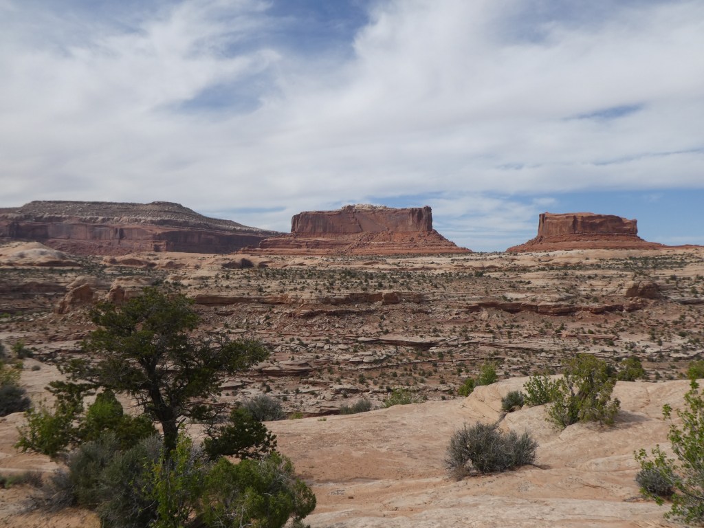

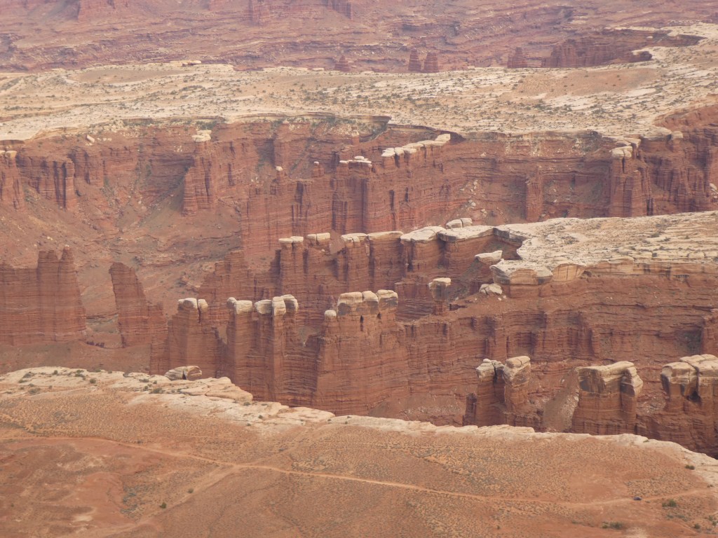
The Merrimack and Monitor are not actually within the boundaries of the national park; it was still many miles from that spot, passing grassland (???) and herds of cattle grazing in the open fields. Though there were signs warning of wait times, the entrance to the park was wide open and after snapping the entrance picture, in I went to National Park 28! After a quick stop at the visitor center I walked across the street to get some spectacular views of the cliffs of the Island of the Sky mesa and the “White Rim,” 1000 feet below stretching as far as the eye could see, and then even further down, another 1000 feet to the canyons that the rivers have carved out. I was very surprised at the expanse of the area leading off to the distant La Sal Mountains. The only sign of civilization was the well known Shafer Road snaking through the cliffs below my vantage point.

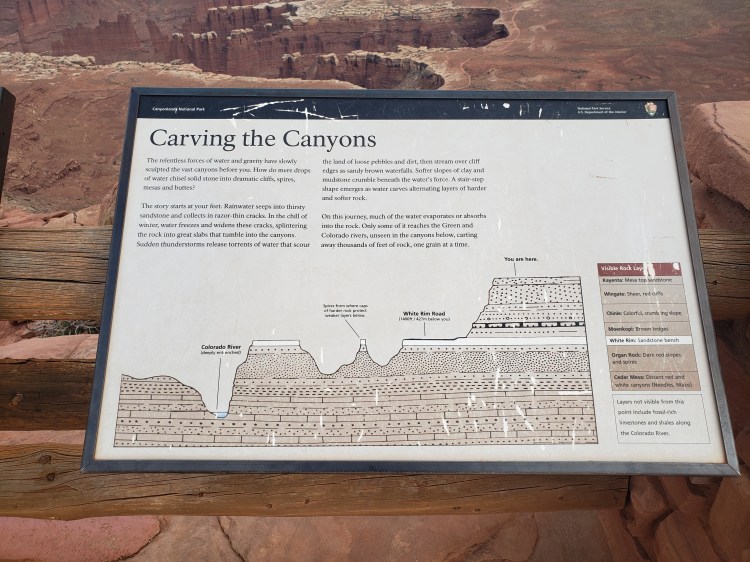
I next crossed the “Neck”, the proper entrance to the Island in the Sky. Now, at this point we might need a bit of geographical information (and you might want to take a peek at the picture under this paragraph) The park actually is the largest in Utah and at 300,000 plus acres is divided into 4 districts. One district is the made up of the Green and Colorado Rivers themselves. Another district is the remote and not easily accessible “Maze.” Another is the also remote but easier to get to (I did not on this trip) “Needles” district. I only visited the Island in the Sky district on this trip, which is the very accessible part of the park. It is called this because it literally is like an Island in the Sky! Once you pass the Neck, you are are on a large mesa wherein you can literally can walk in any direction possible and eventually you are going to walk off of a 1200 foot cliff! No slight slopes down to the bottom, none of that, just pretty much straight falling to the “middle” area of the canyons. Now there are a couple trails and roads (like the Shafer Road) that do get you down there but just assume you’ll fall off a cliff. Also, apparently at times the clouds sit below the mesa and gives a much more convincing visual of an “island in the sky.” Anyway, at the bottom of those cliffs lies the sort of “middle” section of the topography, the white rim. And then from there is the bottom layer, the canyons that are currently hiding the river or recent areas where the rivers have been.
Now that you know a little of the lay of the land, let’s continue! So I ventured past the neck. This was quite a surprisingly green area at this point! In recent history farmers kept their cattle up on this mesa and gated off the neck. The cows could go anywhere because of the cliffs! And there is a large amount of grassland in this section! Also, it is worth noting that ancient Puebloans lived up here as well and some of traces are still seen in the area! There is essentially one paved road through the area, and it goes essentially from the park entrance, through the neck and all the way to the southern point of the mesa, with an offshoot to the west to another chunk of the mesa. This was my path. I would consider this park to be more of a driving and get out and walk park more than a big hiker park. But that was quite ok for my tired self! I stopped pretty much everywhere the Gypsy Guide said and still did do a couple walks/hikes.
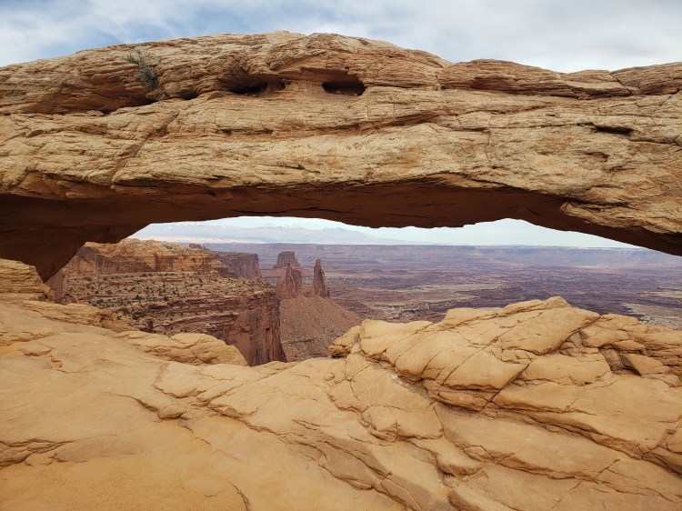
First up was the Mesa Arch! This is one of the big draws of this park and can be pretty busy. I was not there at sunrise or sunset, so it wasn’t too bad! Cool little feature for sure! The hike from the road was not too long at all, and there is a little loop you can do rather than out and back. Bonus, you can hike along the edge of the cliff to the side of the arch and get yourself in a position to see it from the other side, sort of! Also, I do have a gripe. People can be rude. Though there was not a large crowd there, a couple dudes decided to just sit down basically right in a spot in front of the arch that basically impeded everyone’s view…and they were in no hurry to move. I mean, come on!

From there I drove all the way to the end of the road to Grand View point and did a good chunk of the overlook trail there. Also in this area is the Orange Cliffs view where you can see….well…cliffs that are kinda orange in the sun! You also get a viewpoint of the Maze area from up here. This was probably my favorite spot in the park. It was deserted, and had some killer views! It also had some sweet opportunities to hike around and explore without being bothered, just watch your step!


The last segment of my day was the drive back to the exit, but I took the offshoot road that I passed by earlier that goes out to Upheaval Dome. Now at this point it was getting late and I was super tired, so I was just doing some recon for the most part for potentially the next day. However, the sun was lower in the sky and the Gypsy Guide was quite insistent on taking a peek at the Green River Overlook, which was maybe one of the only spots to see that river from this district of the park. Then it was off to Moab Brewery for dinner and beer and then back to my hotel for another super early start for Arches National Park.

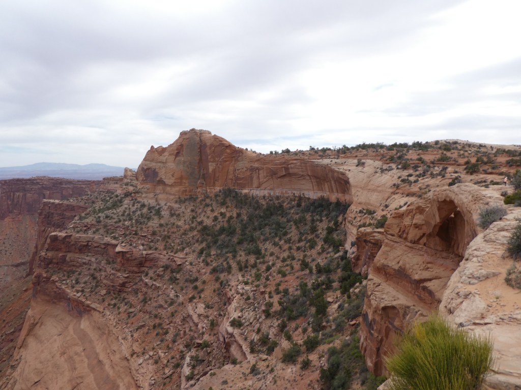
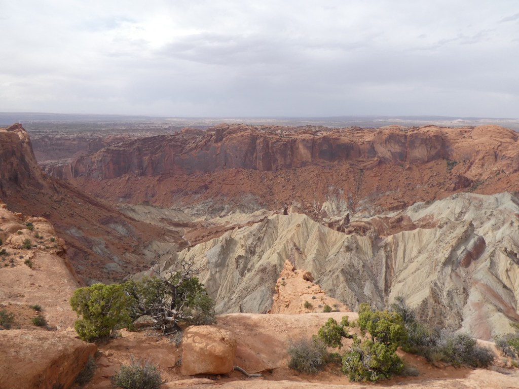
I am doing a separate post on my visit to Arches, but after I finished my day there I came back to Canyonlands for the late afternoon! When I was leaving the previous day from Upheaval Dome, there was another hike the Gypsy Guide strongly suggested so I was looking forward to two more hikes. After revisiting the Shafer Road viewpoint I headed straight for Upheaval Dome. The hike to the overlook for the dome was not much to write home about, but the dome itself is a fairly neat looking feature in the park! The dome itself is somewhat of a mystery! One thing that is very cool about this area is how you can see the different layers of rock throughout the cliffs and canyons. These layers tell the history of the rock. The rock that is visible at the top of the dome is quite old and should not be where it is. I had seen some of that color in small areas and it was way at the bottom of the cliffs, but in this spot that color was pretty far up. There are two disputed theories, one being a meteor impact, and the other being that a layer of salt compacted by the weight of the rock above created a bubbled or sorts that deformed the land above it. It seems that new evidence points to the meteor impact, happening around 60 million years ago! Cool!
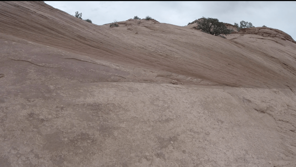
My last stop in the park was a…half fulfilling… hike called Aztec Butte. The hike wasn’t really long, but a part of it seemed very sketchy so I only did part of it. The hike starts easy enough, a sandy walk around a smalle butte. About 3 tenths or so in there is a split to actually ascend that butte. On top are some nice views of the area. There is also a spot where you can get down on some ledges on the side of the butte and access some old Puebloan granaries, they are original, and they are small…but neat nonetheless and several hundreds of years old. They are very well hidden on purpose, even from local wildlife. The next part of the trail, however, seemed like a much bigger payoff but it seemed a bit perilous to me. This part also made an ascent up a butte, but this one was much bigger. There was no path per se, just cairn markers up the side on the very steep “slick rock”. (Slick rock will be mentioned more in the Arches entry – but it’s essentially very smooth sandstone, pretty steep, but provides good grip, unless it’s wet). To be honest, I gave it a fair shake! Here were my issues. Number 1, it had become quite windy. Number 2, it has become very cloudy and the clouds looked rainy. Number 3, I was literally the only person there as it was quite land in the day now. Those three factors together spelled the end of the hike. Supposedly I missed some ruins on the top and some more intact type of structures on the cliffs edge, which I read are quite treacherous to get to anyway. So that concluded my Canyonlands experience!


Overall impressions: Before I get to my nifty Final Word blurb…I don’t want to use the term “hating on”…a lot of people seem to put this one low on their list of Utah parks. To each their own, I rather thought this was an amazing place that requires a little more preparation and equipment than I was able to give to it. Pros: Awesome, VAST, and other-wordly views. If you ever wanted to go to another planet and cannot, ahem, I don’t think you can get much closer than here. If you want to see several awesome things and have limited time, you certainly can do that. This is a park that is very drive friendly without much in the way of any challenging hiking, for the most part. There also was almost no one here when I was there (but I don’t know if that’s normal or not!) Cons: The spread out districts make a good exploration of all of the park very difficult. Outside of the visitor center there is only one other spot to really stop and chill, at the trailhead of the Upheaval Dome. There were toilets sprinkled about, but even the ones at the visitor center were composting. The visitor center has very limited supplies and it’s about 25 miles from the main highway …and the gas station there is pretty ill stocked as well!
The Adventurer Final Word:
Giving this one a 4 star rating! They can’t all be 5s and I gave Zion a 4.5.

Great post and I loved the videos. And I agree with your rating, while Canyonlands was great, the others Arches, Zion and Bryce all surpassed it. We didn’t have a four-wheel drive so we took an excellent guided jeep tour based out of Moab. She showed us where the final scene from Thelma and Louise (you may be too young) was supposedly filmed in the Park. One other comment – the road is kind of hairy on the turns, but especially so if you encounter another vehicle coming the other way!
LikeLiked by 1 person
So, I will confess, I didn’t read all of this, but I love looking at the photos! When we were there, it rained when we got there, and rained when we left. But the sun came out in the middle! We thought it was amazing. But my favorite parks were Bryce Canyon and Arches. It was not super crowded when we were there, but everyone got in my way at Mesa Arch, which annoyed me! Great photos and videos!
LikeLiked by 2 people
Hahah…that’s usually what I do as well! That’s why I try to put a lot of pictures in! I know it makes the block look terribly lengthy, but I’d rather let a reader make the decision if they want to read or get the gist of it from photos! The lengthy prose is really my safeguarding what I am afraid is the very beginning stages of memory loss that has affected a large number of my family! I don’t really forget trip things, mainly mundane, everyday things, but just in case it becomes and issue I know this will be here!
LikeLiked by 2 people
I am saving all of my travel posts to PDF on my computer! I’ve almost run out of space on my blog. I learned too late to make my photo size smaller. So I’m going in and deleting some of my least favorite posts and photos. What great memories for us! 😊
LikeLiked by 1 person
Just an opinion, but Island in the Sky is a definite 5 at sunrise, providing you run out to Dead Horse first (left turn, on the way to the visitor center). It is nothing short of epic. Arches just doesn’t lend itself to beautiful landscape shots except the iconic Delicate arch. Not to say the arches aren’t interesting and the odd rock shapes, but it’s missing the river (from Dead Horse), the awe inspiring heights (with good light), the White Rim and the expansive vistas. The battle ships are more like the views found in Arches (interesting object sitting in the desert, but aesthetically mild).
I noticed you were shooting in overcast – these kind of beg for a little post processing.
I sure enjoyed your shots. Made me want to return.
LikeLiked by 1 person
Yes, I would love to get some good hands on with making the pics better for those type of days! My visit was unfortunately made short due to an annoying airport situation, so it was either or for the early morning spot! It was also overcast that morning, so I made the decision to do delicate arch instead! Had it been sunny that may or may not have changed my plan. It was plenty hard enough to get a picture of the mesa arch without human interference the mid afternoon before! Thanks for reading
LikeLike
Also, I don’t know how I didn’t see your comment until now! 😉
LikeLike