National Park Count: 29
Somehow…part 2!
Hey there adventurers! To clarify the subtitle…you can read part 1, specific to my visit to Canyonlands, or…you can just read the next couple sentences! Long story, short, I had some travel ado, slept on an airport floor, arrived late to Utah with next to no sleep, and began my second Utah adventure! (You can check out my first adventure in Utah, with the Sidekick, here.) After a pretty fierce tour of most of what I wanted to experience in Canyonlands I began my visit to Arches National Park.
As a reminder, I have a post on tips and tricks for visiting national parks. Something as simple as merely visiting (and actually reading) park websites is a must. It is critical, now, to be aware of timed entry requirements and other potential ticketing requirements. I also detail the IMMENSE importance of getting into parks (especially busy ones) before sunup. Arches is one of these parks. I had not secured a timed entry pass as of the night before so I got up around 4 AM to head to Arches. But, I thought, hmm..let me check anyway, just in case. I found a 6 AM pass available and snagged it! (This proved to be a very important item in a couple hours!). From my hotel, I drove the hour or so to the entrance and arrived at 5.30 AM. I will add, that even at this early hour, the entrance station was manned, so you aren’t avoiding entrance fees at the early pre dawn hours, but buy a damned annual parks pass and be a decent human being! In any event, pre 6 AM you do not need a timed entry pass. BUT…I learned a few potentially helpful things! After showing my parks pass, the ranger cleared me in, but I wanted to clarify that I could leave and come back since I had a 6 AM pass. She said, oh, yes, but I have to scan it first, otherwise you cannot. Weird. Had I not specifically asked, she would mot have scanned my pass and I would NOT have been able to re-enter! Unbeknownst to me, I had a GoPro micro sd card that was dangerously close to full after my first hike…and the visitor center has the regular sized ones to buy, but not the little ones. So, at about 8 AM I actually did need to leave the park to go into Moab. Thank goodness I had snagged that pass! But…when I came back in that ranger looked me up and THEN said he ALSO needed the park map!? Well, since I collect and display them, of course I had it from a just a few hours earlier, but what if I had lost it? Or went back to a room and dropped it off? He said point blank, no re-entry without it…and he even put a pink sticker on it and said I had to show to another ranger monitoring at the roundabout. And she did check. Whoa. Super strict, AND none of this was on the website, mind you. The rec.gov site simply says if you have a pass you can leave and come back it. I am not really sure what the problem is if I had a 6 AM pass and came in, left and came back, verus, I DIDN’T come in at 6 and instead came in at 10….really those two make no difference at all…but it is what it is. Just make sure you have the rangers scan your pass if you go in ahead of hours, and make sure you have your map!
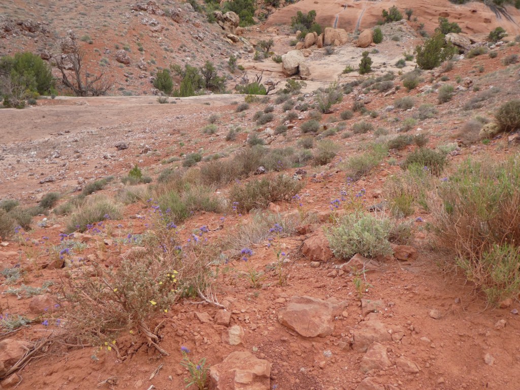
Ok, so after all of that, off to fun Arches stuff! So I have to say this park is pretty small, but pretty damn amazing! Right off the bat this place is super neat! Even the entrance is on point! Once you pass the station to take short windy road up and then boom, there it is! The park opened in front of me. It really looks like another planet! Off in the distance is the ever vigilant La Sal Mountains, and in the nearby landscape is this huge open area of petrified sand dunes (that term doesn’t actually make sense to me, but it is what it is…). So the entire park sits on top of a lot of salt that was laid down millions of years ago. The area was underwater. Then it wasn’t, then it was, and repeat. In between, stuff was laid down on top of the salt over time and became rock. All this rock sits on top of all that salt. And salt doesn’t stay put, it actually kinda…flows or something. Eventually all the weight on top compresses the salt and forces it into domes and ridges. Eventually the rock on top gives and cracks creating fractures that make rock fins. It is a rare occurrence to actually form an arch, but that part is done by erosion, mostly water, if the conditions are extremely right. Most of the erosion is from the side of a fin, but some arches were formed from pools of water that made potholes that worked their way from the top to the sides of the rock fin. Arches National Park is not the only place in the world, and not even the only place in Utah, or even in the Moab area to have arches, but it does have the most in one spot on the planet, at over 2 THOUSAND!

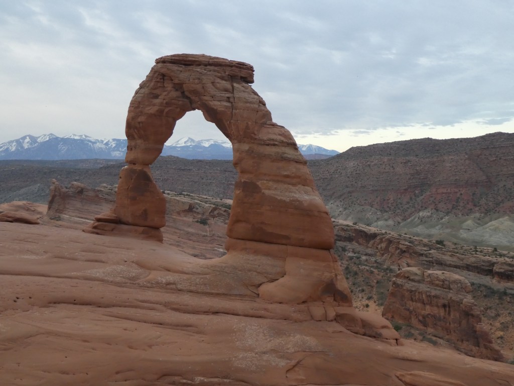
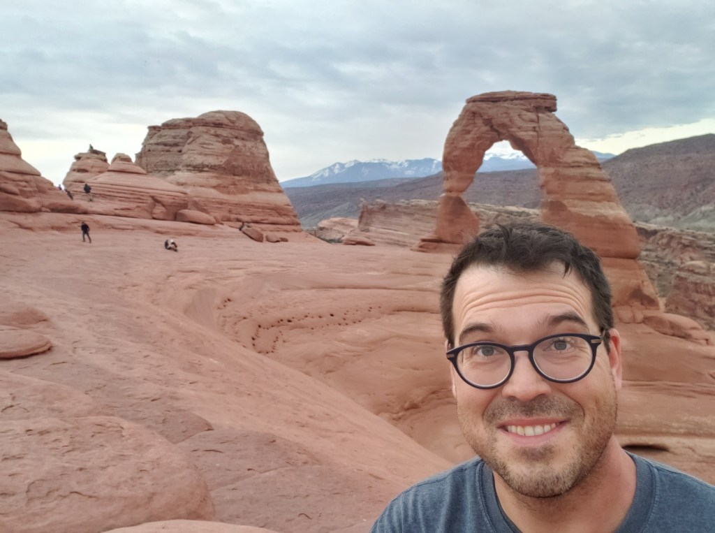
My first stop was Delicate Arch! As I came in early, the park was DESERTED. There was nearly no one there. At 5.45 AM there were maybe 6 cars in the lot. That was it. It was not quite sunrise, but I would not be able to make it in time. However, I wasn’t concerned about that as the sky was wonderfully filled with clouds…so, anyway, I did the hike to the arch. The hike itself is about 3 miles round trip. It’s not terribly difficult or painful…except for one bastard area. There is a pretty lengthy stretch of very steep slick rock. Going up actually wasn’t too much of a problem, but going down was not kind at all, at all, at all! But, I digress! After 1.5 miles of hiking, and going around the last corner, there she was! The most famous landmark in the park, the arch featured on the Utah state license plate, the Delicate Arch. There were people there, to be sure, but maybe 20? It was beautiful and serene. Had there been a decent sunrise it might have been better, but as it was, it was just perfect! I stayed up there a bit, had a snack, took some photos, lamented my lack of a beer to frame in the arch (what was up with that? I had beer with me, just in the car, and didn’t take any beer pictures at all in Utah!?), and just existed. The spot I choose to park myself down on was empty of people and gave a great arch frame of the La Sal Mountains as a backdrop! Upon leaving I was very dismayed to discover that I did, indeed, have to go back down the way I came up. That meant dealing with that slick rock spot. As I ascended this spot, there was a little nugget in the back of my brain that I was not going to be a happy camper coming back down. The knees are not great so this was rough. Going up is rarely a problem. It is always the going down that is a hassle…and this was really not cool. I sorta took it personally too. (Don’t worry, I might have called the rock a m*****f*****, but I later asked forgiveness from another rock and was not squished to death, so I think we are all good!) Anyway, as I finished coming down, I took an offshoot trail that goes to some old native petroglyphs. Whenever I see stuff like this, I cannot help but stand in awe at the history and the circumstances of the people who first discovered and settled in areas like this.

This is the point that I discovered my GoPro memory card had 2 measly minutes of recording time left, so at this point I left the park and returned restocked, 30 minutes later. Interestingly, the line to get in was still only 2 or 3 cars, and it was well after 8 AM. After re-entering I then decided to make some stops as per the Gypsy Guide and get in some learning about the park! The drive down the main road is replete with awesome things to see straight from the car! I went off from the main drag and headed down a side road to another cool area that features a balanced rock, people with larger huevos than I, climbing up the side of these sheer rock formations, and many, many more arches. I also found probably my favorite part of the park, The Windows area.
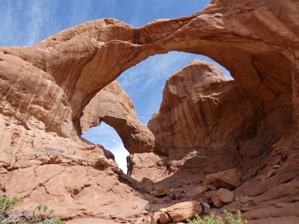
This area is access by the Windows Road and leads past several cool things to a very large arch feature called, appropriately enough, The Windows. This whole area is probably my favorite spot in the park. The walk to the two windows is nice and easy with cool things to see. And then, you can actually get into the thick of the arches, both The Windows and also the nearby Turret Arch. As I have said many times, people in national parks are very predictable. The trail to the north and south windows contained the most people. There is a side trail that goes off to Turret Arch. It was nearly empty. Shocking. And, even though the two Windows Arches are physically joined and just require a pretty short extra walk, the people going to the south one were much fewer than the crowd hanging around the north window. Additionally, you can go around the south arch and get into a little nook that it helps form and just chill there. And then, there is a primitive loop trail that goes entirely behind the whole area. NOT ONE SINGLE PERSON. Not one. Not one single solitary person was on that trail other than me. It is a pretty sweet way to see a part of the area without humans around! The trail is not marked other than a couple signs informing you that way isn’t it, and some cairns. But, it isn’t like you can really get lost or anything. I also found it interesting how part of this trail went through a very heavy vegetative section. I suppose this little nook must afford some better living conditions!


After making my way off the primitive loop trail, it was a short walk down the road to access the Double Arch Trail. This trail is another easy one, just a bit longer. There are lots of cool animal looking features in this are. One definitely looks like an Elephant and that feature is called the Parade of Elephants. This area was more crowded, but still not bad. There are, shockingly enough, two arches that make up the Double Arch. They were both formed as a pothole that eroded down from the top, rather than from the side, as is more common. This one is actually the tallest in the park and also the second widest. With a little scrambling and climbing there is a way to climb up into the actual arch opening and see the view out of the window to the back side. The back is a pretty sheer drop that would not end well, so watch your footing! Following this, I passed brave climbers in the Garden of Eden area and watched them for a minute as they climbed the hoodoos here. Those people are nuts! Anyway, I made my way out of The Windows area and headed to the very end of the park drive.

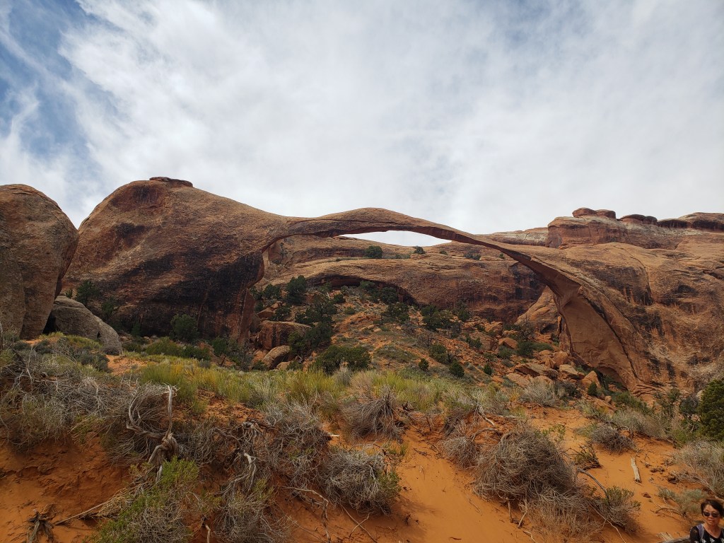
After a stop and talk with a ranger at the Fiery Furnace area of the park – you can’t do this hike on your own without a ranger and a permit – I made it to the Devils Garden area of the park. This is the end of the road and the start of the Devils Garden Trailhead, which was my next stop. There is quite a large parking area here, but at about 11 AM or so, this area was pretty packed and I found one of the last parking spots available at the end of the loop! This is a nice trail. It was quite hot at this point, but the trail starts in a slot between fins that keeps you shaded for a bit. There are many rock fins in the area giving some neat formations to look at throughout the hike. My destination was Landscape Arch but there are a couple side arches to be seen as well, so I did those also. One of those is my “educational” picture early on in the post, Pine Tree Arch. Landscape Arch is the longest natural stone arch in the world at 290 feet long. Relatively recently, a big section of it collapsed and now there are parts that are only SEVEN feet thick. Whether this spells the beginning of the end of the arch or the arch merely shedded excess weight and increased it’s longevity remains to be seen, but in any event, you could once hike right under it (a not pleasant looking hike to be sure) but now have to see it from a bit of a distance. Still, a very cool thing to see! Now, at this point I had a decision to make, this trail actually goes on for a quite a while longer and to see some more awesome stuff. If I return to Arches I will probably do it. But on this day, my knees were tender after coming down from the Delicate Arch hike, so I turned back. Plus it was pretty intensely sunny and pretty warm. Also, it was approaching lunch time!

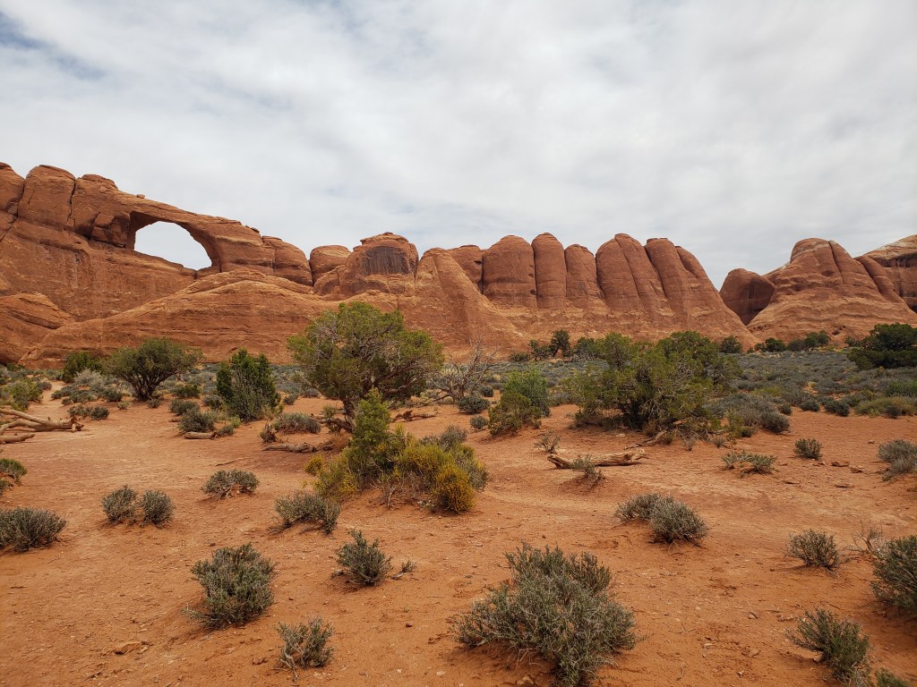
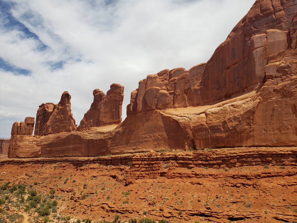
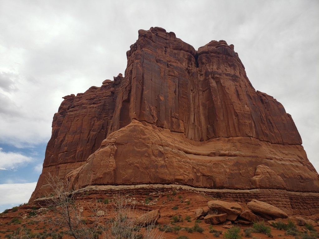
After departing the Devils Garden area I made a few stops before departing the park. I stopped and did a mini hike to get a view of Skyline Arch. I stopped at the Courthouse Towers and the Park Avenue area. There is a hike to be done on a future visit as well…but see the last sentence of the previous paragraph! So that concluded my visit to Arches National Park, National Park Number 29!
Overall impressions: This place is stunning. Really, a very unique place on planet earth. It is very close to a town, rather than the 25 or 30 miles Canyonlands is (in case you need something…oops). I could be wrong about this, but I feel this park had more places to stop and relax and there some decent hiking opportunities if want, but yet you could see many of the awesome things in the park without leaving the car too far behind. That being the case there are 2 knocks. The timed entry is one. There is nothing to be done about it either, so it is what it is. And, even though I missed some things, I still feel the park is quite small and somewhat limited in scope of things one can do.
The Adventurer Final Word:
Giving this one 4.5 stars! I am not sure if it was better than Zion or not, so it gets the same rating!
