Hey there Adventurers! I haven’t even finished my Arches entry yet (that’s coming later today or tomorrow) and here I am on the verge of more cool shit! Next week I am getting on a plane and headed to the land of the midnight sun! (go here to read about my 2017 Alaska trip!) I don’t want to say this trip snuck up on me (I planned this one back in February after all!) but this is a big trip and I feel like the time has flown by!
Anyway, weather permitting my rough itinerary: Day 1: Land in Anchorage, get rental car, stop at Midnight Sun Brewing Co. Get to Girdwood and check out the scene that evening and Girdwood Brewery Co. Day 2: Boat tour to the Kenai Fjords National Park with Kenai Fjords Tours hang in Seward, Seward Brewing Co. Day 3: Hike in the park/Seward area, check out the Alaska Sealife Center. Day 4: Work my way back to Anchorage and explore some other parts of the Kenai, Cooper Landing Brewing Co and maaaaybe Kenai River Brewing Co, but it’s a bit far…and I also want to check out the Alaska Wildlife Conservation Center. Day 5: Bush Plane ride with Lake Clark Air to Port Alsworth on Lake Clark. Day 6: Hang around Anchorage all day, maybe do Flattop Peak, overlooking Anchorage midnight flight back to Florida!
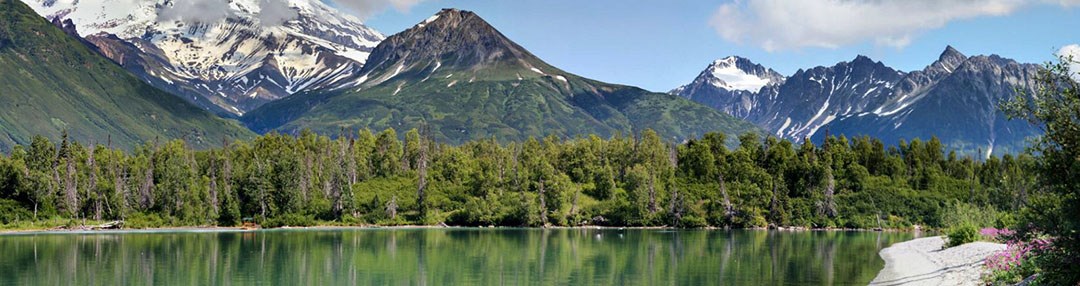
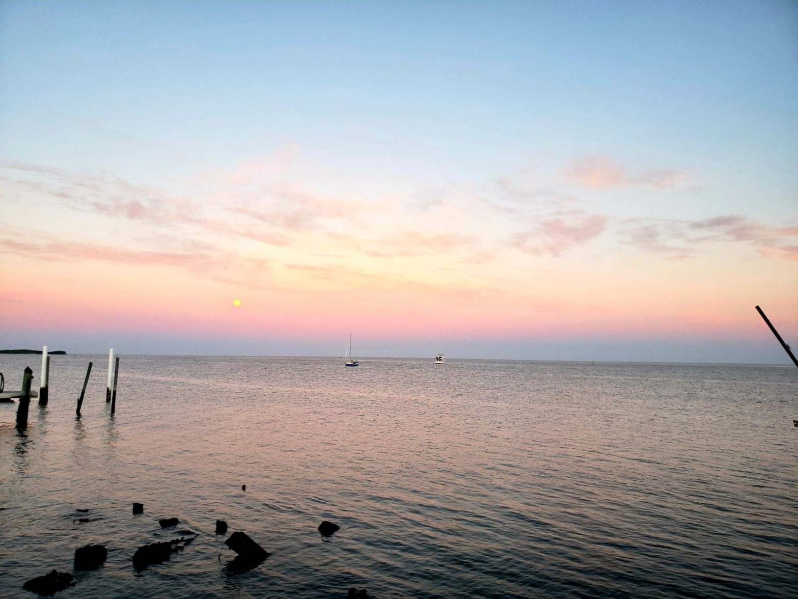
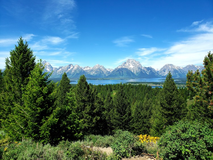
The featured image is one of the NPS pictures of Lake Clark. Obviously, I havent been there so next time I post a Lake Clark picture it should be my own! Temps are looking like mid 60s/high 40s! Sunrise around 4.30 AM/Sunset about 11:30 PM. In Anchorage, even, the last night that got to Astronomical Night was May 6. The darkest I will have is the sun between 6 and 12 degrees below the horizon before it starts coming up again!
I would like to quickly add that this was an expensive flight, (like $8-900) entirely free via my new handy Alaska Airlines Credit card. If anyone is interested in learning more, feel free to ask!
Lastly, I am planning on doing some mid-trip updates if I am in spots with working wifi! Be sure to check in later next week! And be looking for that Arches post very soon!
Greetings fellow adventurers! Well, my whirlwind travel habits nearly derailed me this time! Thankfully I was able to wrestle a positive experience out of the jaws of disappointment. There was little downtime, little sleeping, and much exhaustion, but I managed to have a pretty satisfying experience of Canyonlands and Arches!
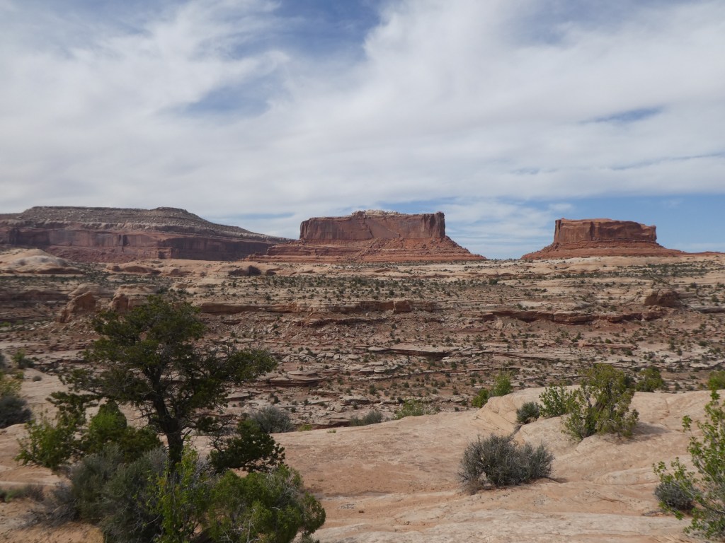
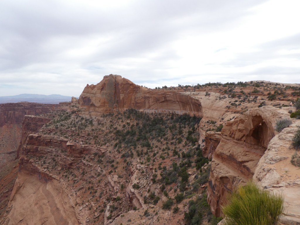
Without getting into too much, I was quite delayed in my arrival with airport and plane issues which got me into Salt Lake much later and with nearly 0 sleep. After retrieving my rental vehicle it was straight out of SLC and on to Green River, UT where my hotel was located. The drive out of Salt Lake was not really what I expected, surprisingly green and with snow capped peaks. These views eventually gave way to the desert as I hit the long stretch to the Motel 6. As a side note, this Motel 6 was actually shockingly decent and only 100 bucks a night! Anyway, I checked in refreshed a bit (remember 2 hours of sleep?!) and then off to the “Island in the Sky” district of Canyonlands. The drive from Green River to Canyonlands is about an hour through the desert But it is all scenic and definitely different from the Florida landscape! After turning onto the road leading into the park I turned on the trusty Gypsy App. It was not long before the first suggested stop came! At this point I will admit some ignorance. I had a general idea of a mesa, and butte, and a plateau…but this area is full of them and I wouldn’t have been able to tell you one from the other. The Gypsy guide was quick to educate on all the relevant terms needed for visiting the park! This first stop was to see two iconic buttes, The Merrimack and Monitor – named after their resemblance to those two civil war ships. This was a fun preview of the rest of the trip where I spent a lot of time making my own names for rocks!
The Merrimack and Monitor. I wasn’t really expecting to need my Civil War history, but here we are! Taken by me.
Surprisingly, many beautiful wildflowers seem to survive in this inhospitable environment! Taken by me.
The Merrimack and Monitor are not actually within the boundaries of the national park; it was still many miles from that spot, passing grassland (???) and herds of cattle grazing in the open fields. Though there were signs warning of wait times, the entrance to the park was wide open and after snapping the entrance picture, in I went to National Park 28! After a quick stop at the visitor center I walked across the street to get some spectacular views of the cliffs of the Island of the Sky mesa and the “White Rim,” 1000 feet below stretching as far as the eye could see, and then even further down, another 1000 feet to the canyons that the rivers have carved out. I was very surprised at the expanse of the area leading off to the distant La Sal Mountains. The only sign of civilization was the well known Shafer Road snaking through the cliffs below my vantage point.
The Shafer Trail, a perilous looking drive from the top of the mesa to the White Rim area. This is the view closest to the visitor center.
Here is a (lengthy) video I took from another viewpoint of this trail/road. Worth a view I think! Taken by me.
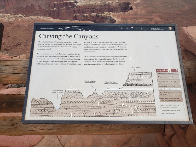
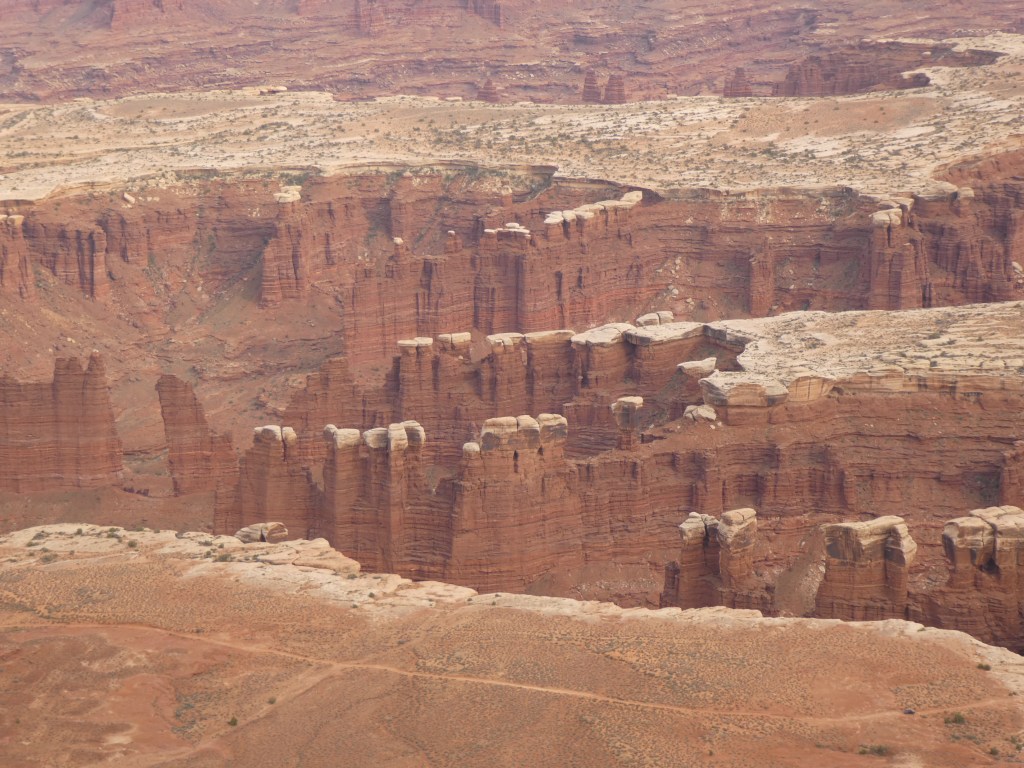
I next crossed the “Neck”, the proper entrance to the Island in the Sky. Now, at this point we might need a bit of geographical information (and you might want to take a peek at the picture under this paragraph) The park actually is the largest in Utah and at 300,000 plus acres is divided into 4 districts. One district is the made up of the Green and Colorado Rivers themselves. Another district is the remote and not easily accessible “Maze.” Another is the also remote but easier to get to (I did not on this trip) “Needles” district. I only visited the Island in the Sky district on this trip, which is the very accessible part of the park. It is called this because it literally is like an Island in the Sky! Once you pass the Neck, you are are on a large mesa wherein you can literally can walk in any direction possible and eventually you are going to walk off of a 1200 foot cliff! No slight slopes down to the bottom, none of that, just pretty much straight falling to the “middle” area of the canyons. Now there are a couple trails and roads (like the Shafer Road) that do get you down there but just assume you’ll fall off a cliff. Also, apparently at times the clouds sit below the mesa and gives a much more convincing visual of an “island in the sky.” Anyway, at the bottom of those cliffs lies the sort of “middle” section of the topography, the white rim. And then from there is the bottom layer, the canyons that are currently hiding the river or recent areas where the rivers have been.
The Park Service info card does a much better job describing the area. Open it in a new tab to zoom in if you would like!
Now that you know a little of the lay of the land, let’s continue! So I ventured past the neck. This was quite a surprisingly green area at this point! In recent history farmers kept their cattle up on this mesa and gated off the neck. The cows could go anywhere because of the cliffs! And there is a large amount of grassland in this section! Also, it is worth noting that ancient Puebloans lived up here as well and some of traces are still seen in the area! There is essentially one paved road through the area, and it goes essentially from the park entrance, through the neck and all the way to the southern point of the mesa, with an offshoot to the west to another chunk of the mesa. This was my path. I would consider this park to be more of a driving and get out and walk park more than a big hiker park. But that was quite ok for my tired self! I stopped pretty much everywhere the Gypsy Guide said and still did do a couple walks/hikes.
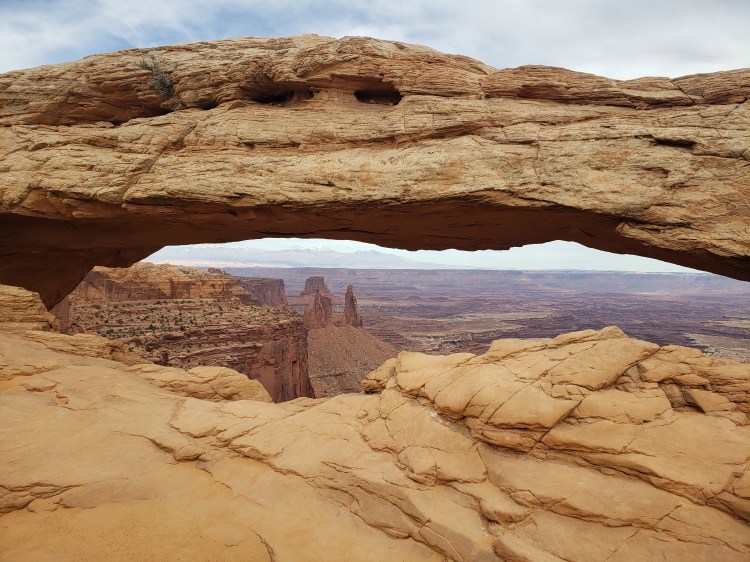
First up was the Mesa Arch! This is one of the big draws of this park and can be pretty busy. I was not there at sunrise or sunset, so it wasn’t too bad! Cool little feature for sure! The hike from the road was not too long at all, and there is a little loop you can do rather than out and back. Bonus, you can hike along the edge of the cliff to the side of the arch and get yourself in a position to see it from the other side, sort of! Also, I do have a gripe. People can be rude. Though there was not a large crowd there, a couple dudes decided to just sit down basically right in a spot in front of the arch that basically impeded everyone’s view…and they were in no hurry to move. I mean, come on!
Pretty wild flowers, again, how weird!?, in the Mesa Arch Area. Taken by me.
It wasn’t sunrise or sunset, but I think of a very limited amount of people made for a much more enjoyable moment! Taken by me.
So, no one was venturing up here, so I thought it was a good spot to check out the other side of the arch, which, if you can’t see it, it’s on the middle right of the picture and you can just barely make out a small opening there. Taken by me.
From there I drove all the way to the end of the road to Grand View point and did a good chunk of the overlook trail there. Also in this area is the Orange Cliffs view where you can see….well…cliffs that are kinda orange in the sun! You also get a viewpoint of the Maze area from up here. This was probably my favorite spot in the park. It was deserted, and had some killer views! It also had some sweet opportunities to hike around and explore without being bothered, just watch your step!
A shot along the trail of the Grand View Point. There is a road down there. That one is drivable with a permit! Taken by me.
Another spot along that Grand View Point. Taken by me.A peek of the “Orange Cliffs” I had to venture out pretty far and off the beaten path for this! Taken by me.
Quick video of the area of the Orange Cliffs. Taken by me.
The last segment of my day was the drive back to the exit, but I took the offshoot road that I passed by earlier that goes out to Upheaval Dome. Now at this point it was getting late and I was super tired, so I was just doing some recon for the most part for potentially the next day. However, the sun was lower in the sky and the Gypsy Guide was quite insistent on taking a peek at the Green River Overlook, which was maybe one of the only spots to see that river from this district of the park. Then it was off to Moab Brewery for dinner and beer and then back to my hotel for another super early start for Arches National Park.
This has a name but I cannot remember it at all. Easily seen from the road! Taken by me.
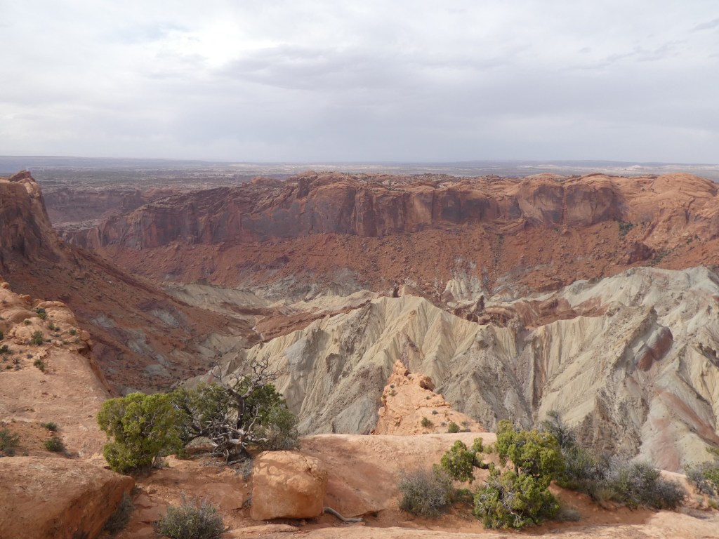
I am doing a separate post on my visit to Arches, but after I finished my day there I came back to Canyonlands for the late afternoon! When I was leaving the previous day from Upheaval Dome, there was another hike the Gypsy Guide strongly suggested so I was looking forward to two more hikes. After revisiting the Shafer Road viewpoint I headed straight for Upheaval Dome. The hike to the overlook for the dome was not much to write home about, but the dome itself is a fairly neat looking feature in the park! The dome itself is somewhat of a mystery! One thing that is very cool about this area is how you can see the different layers of rock throughout the cliffs and canyons. These layers tell the history of the rock. The rock that is visible at the top of the dome is quite old and should not be where it is. I had seen some of that color in small areas and it was way at the bottom of the cliffs, but in this spot that color was pretty far up. There are two disputed theories, one being a meteor impact, and the other being that a layer of salt compacted by the weight of the rock above created a bubbled or sorts that deformed the land above it. It seems that new evidence points to the meteor impact, happening around 60 million years ago! Cool!
Upheaval Dome….you decided! Impact or salt dome deformation? Taken by me.
My last stop in the park was a…half fulfilling… hike called Aztec Butte. The hike wasn’t really long, but a part of it seemed very sketchy so I only did part of it. The hike starts easy enough, a sandy walk around a smalle butte. About 3 tenths or so in there is a split to actually ascend that butte. On top are some nice views of the area. There is also a spot where you can get down on some ledges on the side of the butte and access some old Puebloan granaries, they are original, and they are small…but neat nonetheless and several hundreds of years old. They are very well hidden on purpose, even from local wildlife. The next part of the trail, however, seemed like a much bigger payoff but it seemed a bit perilous to me. This part also made an ascent up a butte, but this one was much bigger. There was no path per se, just cairn markers up the side on the very steep “slick rock”. (Slick rock will be mentioned more in the Arches entry – but it’s essentially very smooth sandstone, pretty steep, but provides good grip, unless it’s wet). To be honest, I gave it a fair shake! Here were my issues. Number 1, it had become quite windy. Number 2, it has become very cloudy and the clouds looked rainy. Number 3, I was literally the only person there as it was quite land in the day now. Those three factors together spelled the end of the hike. Supposedly I missed some ruins on the top and some more intact type of structures on the cliffs edge, which I read are quite treacherous to get to anyway. So that concluded my Canyonlands experience!
These buggers are well hidden and well protected! What is not seen is a pretty steep curve to my left and down. The edge of the top of the butte is visible and to get up there required navigating a crack that is obscured by that tree’s left vertical branch. Don’t trip there. You wouldn’t like the results. At least not for very long!. Taken by me.
Here is the slope. The Pueblo granaries are in the black nook there in the middle. Taken by me.If you look closely toward the center top you can see a cairn marking the “trail.” The payoff is pretty far up there and seemed suspect to me with the wind and the rainy looking clouds coming from behind. Taken by me.
Overall impressions: Before I get to my nifty Final Word blurb…I don’t want to use the term “hating on”…a lot of people seem to put this one low on their list of Utah parks. To each their own, I rather thought this was an amazing place that requires a little more preparation and equipment than I was able to give to it. Pros: Awesome, VAST, and other-wordly views. If you ever wanted to go to another planet and cannot, ahem, I don’t think you can get much closer than here. If you want to see several awesome things and have limited time, you certainly can do that. This is a park that is very drive friendly without much in the way of any challenging hiking, for the most part. There also was almost no one here when I was there (but I don’t know if that’s normal or not!) Cons: The spread out districts make a good exploration of all of the park very difficult. Outside of the visitor center there is only one other spot to really stop and chill, at the trailhead of the Upheaval Dome. There were toilets sprinkled about, but even the ones at the visitor center were composting. The visitor center has very limited supplies and it’s about 25 miles from the main highway …and the gas station there is pretty ill stocked as well!
The Adventurer Final Word: Giving this one a 4 star rating! They can’t all be 5s and I gave Zion a 4.5.
Hey adventurers! My first ever mobile post and curious how it works compared to on the computer! Anyway, I am writing to you from a plane at the Denver Airport about to depart to Salt Lake…and I was intending to be halfway between Salt Lake and Moab right now, so obviously there were issues! Gonna make the best out of what I got dealt! I kinda always envisioned my National Parks tour as a more quick taste and then find the ones I really want to spend lots of time at later in life, so I am not gonna stress anything! Till the next time, do cool shit!
Greetings fellow Adventurers! I dilly dallied and struggled mightily with my destination this weekend. I was thinking Great Basin but it’s still cold! And, part of the big drive there is still closed for the season. Then, I was convinced to do Capitol Reef. But the cost of lodging and everyone saying they wished they had more time in Capitol Reef convinced my to get a cheaper hotel in Green River – a 45 minutes drive from both Arches and Canyonlands National Parks. I figure I can get to Canyonlands late morning, hike around the park a bit, see some cool stuff. Maybe catch a sunset at Arches or at Dead Horse State Park. Sunday, go into Arches pre 5 AM and stay all morning/day there and maybe hit some missed stuff at Canyonlands. It’s going to be a very flex trip. I am excited for clear skies, a new moon, and a 4 AM (ish) Milky Way viewing opportunity! Stay tuned for my wrap up next week. In the meantime, if anyone has some tips for cool stuff that is easy to get to from the Moab area, or in the parks, let me know in comments!
Hello fellow Adventurers! Happy National Pet’s Day, which just so happens to be the Bark Ranger’s Gotcha Day! I saved my Bella Brown from a kill shelter 11 years ago! She’s still going strong, too! So the last 2 months have been a bit quiet. I have only done some local Florida traveling in March (see below!) with the Bark Ranger and the Sidekick, although I am still working on some new things for the page and still avoiding organizing some stuff! Until about 2 weeks ago I thought there would be no “big” trips until my first trip to Alaska at the end of May. A Southwest Airlines sale and a favorable weekend itinerary are getting me to hit a couple national parks in Utah in the end of April/top of May.
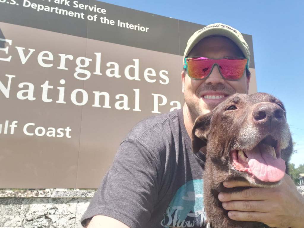
First off though: some Florida travel with the Bark Ranger, and also with the Sidekick and her Bark Rangers. On the first day of our Spring Break I took Bella down to Southwest Florida. For those who are unfamiliar with Florida, the stretch along the bottom of the state is pretty much all remote swampland with only some small native settlements holding on. Cell signal, gas stations, and any services are less available that the gator (literally) crossing the road. Anyway, the reason for the trip was I wanted to take Bella on a short road trip somewhere new (to both of us!) that could get her another Bark Ranger tag! While Biscayne National Park (also has a Park Ranger program, but too far a drive for this trip) sits off the east coast just south of Miami, there are actually TWO national park units that pretty much encompass the entire tip of Florida: The Everglades National Park and Big Cypress National Preserve. The Everglades does not have a bark ranger tag but Big Cypress does! (Sadly they were out of them and as of the time of this post, nearly a month later, I have yet to receive in the mail.
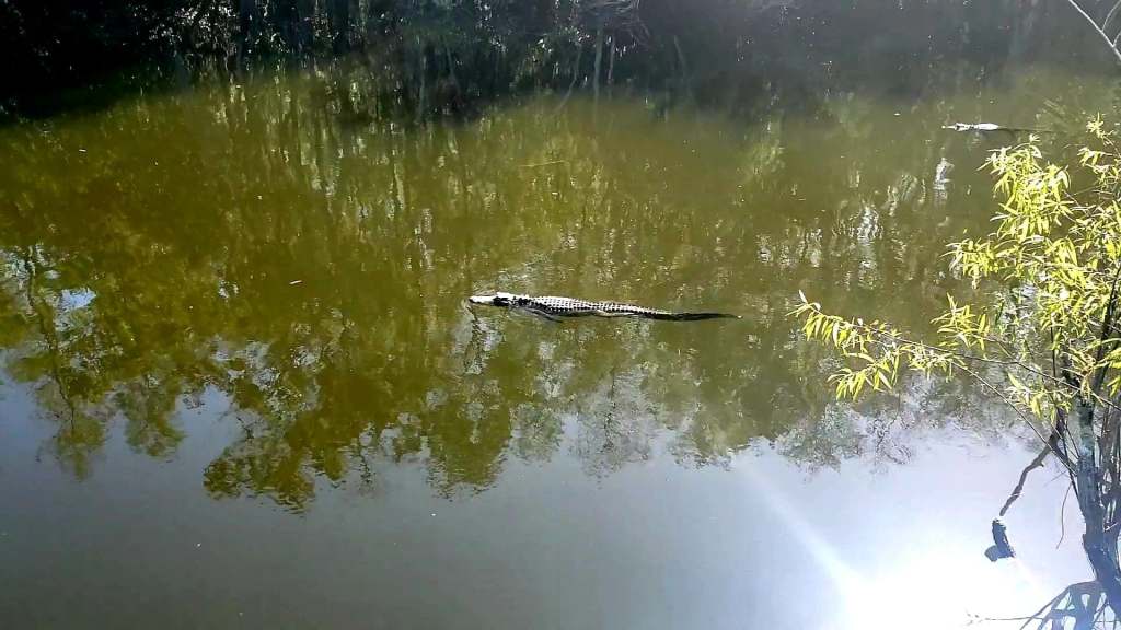
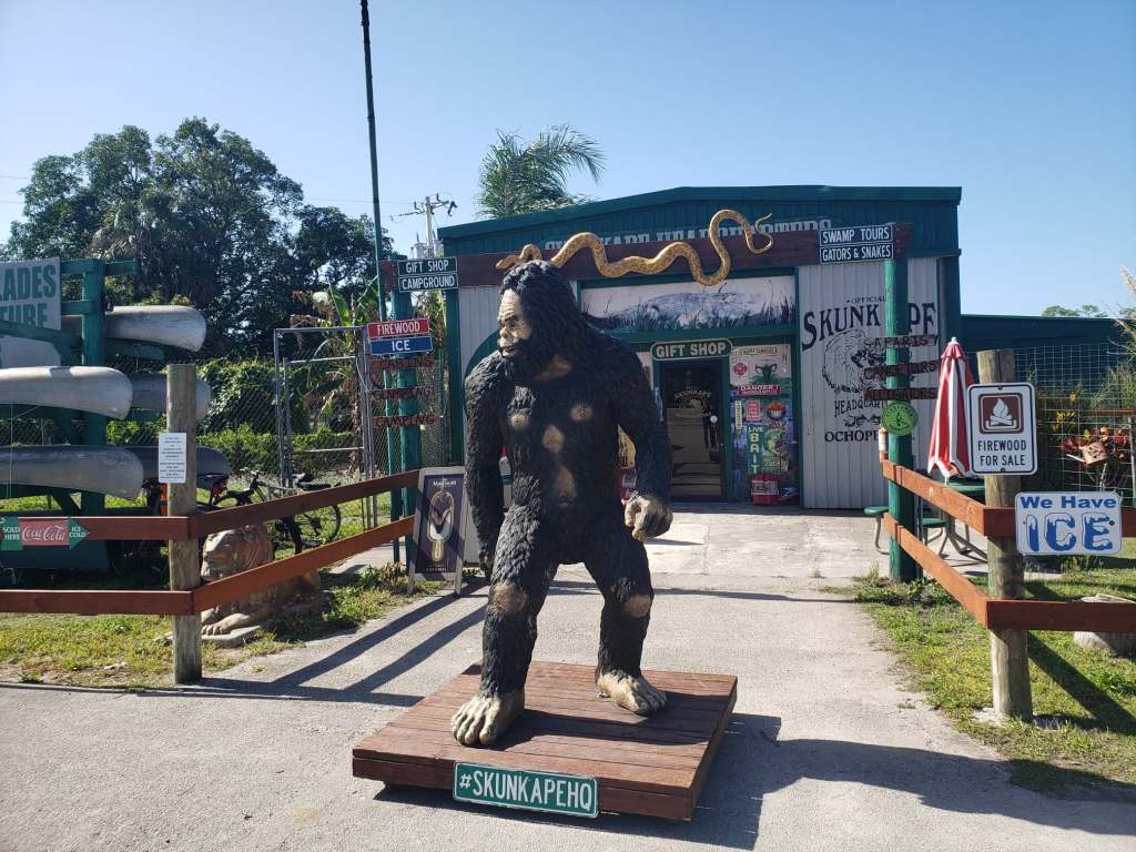
We first went into Big Cypress and drove around a while. We checked out the country’s smallest post office. We stopped at a dinky convenience store/live animal display and saw the Florida Skunk Ape. After driving down a sketchy gravel road for awhile, we found a boardwalk trail to view gators. Probably a good thing that even though this is a Bark Ranger park, they aren’t really allowed out of the car much…for obvious reasons! After stopping in the Visitor Center and failing to secure a badge we left and headed about 20 minutes away to Everglades City, which has an entrance and visitor center to the National Park that I had not been to yet.
Supposedly the country’s smallest post office: Ochopee, FL. Taken by me.
The locals. Bella stayed in the car for this! This is in Big Cypress, taken by me.
Florida is a really….magical place. The skunk ape is the Florida take on Bigfoot! Taken by me.
At this point I should note a couple things that I learned. It is much more remote down there than I anticipated. There are actually very, and I do mean, VERY few things to down in this part of Florida except boating and swamp airboat trips. This part of the Everglades is entirely explorable by water only. There are no trails, no drives…the visitor center here is even a temporary one to fill in for the one destroyed by Hurricane Irma 5 years ago. The Miami side of the Everglades is very much more worth your time and effort. I think Big Cypress is probably in the same boat…even though there were some drives and a proper visitor center, there is a much better area closer to Miami. I do not want to discourage anyone from exploring Florida, but really…this section of the state is very uninteresting and you should skip it if planning an outdoors trip in Florida.
I am really not choking her, I promise!
The sign for Everglades city is far superior to the parks’ signs around here!
Not only generic and uninteresting, but also not ever remotely situation in a picture friendly spot!
Later in the week, the Sidekick, her dogs, and myself got into our respective vehicles and headed north from the Tampa area for two nights in Cedar Key to enjoy some quiet dog time for St. Patrick’s Day. This is another very remote location about 2/3 up the Florida Peninsula on the west coast. About an hour from Gainesville, and 2 from Tampa you will find Cedar Key as a throwback to Old Florida, about 20 miles away from a main road. In contrast to the earlier trip this area is indeed much more dog friendly. The whole town seems to be welcoming to the pooches, including most bars and restaurants. There aren’t many to be sure, but I think we only saw one place with a no dog sign. The hotel we stayed in even allowed all three dogs with no issues and no fees! We found ourselves in the middle of a charity pub crawl, if you will, and generally just enjoyed the gorgeous Florida March weather and not dealing with the hustle and bustle of the Tampa area. While there were no a ton of things to do here, it was a nice change of pace for sure. And, if you don’t have dogs there do appear to be a lot of other things you can do as well, mostly water based.
A part of the smaller town of Cedar Key. Taken by me.
Sidekick and Bark Ranger Lily.
The Parks Adventurer and Bark Ranger Bella.
Sidekick and Bark Rancher Charlie!
Now, for the rest of my post points! I am still trying to decide on what to do in Utah and if anyone has suggestions, I’ll take them! An easy idea is to stay near Moab and that gives me easy access to Canyonlands and Arches National Parks, with potential to swing out for an hour drive to Capitol Reef. The problem with this one is that I never made it to Mesa Verde in southwest Colorado and I was sorta planning on doing that one plus those Moab parks in one go. This trip doesn’t offer enough time to make it to Mesa Verde, so I would have to make a trip just for that one park, although I would love to get back to Telluride again some time! The other option would be to swing down to Capitol Reef for a day and then spend a day in Nevada’s Great Basin National Park. This plan gives a bit more drive time, but does eliminate a park that was also looking like a logistical problem being several hours in the wrong direction…if I get it now, I will not have to worry and I can live Bryce missing because the Sidekick wants to go there some time. Any thoughts?
And lastly, if anyone has some good Bark Ranger pictures or stories to share I am in the beginning stages of something new and I think exciting on the topic of our fur kid rangers!
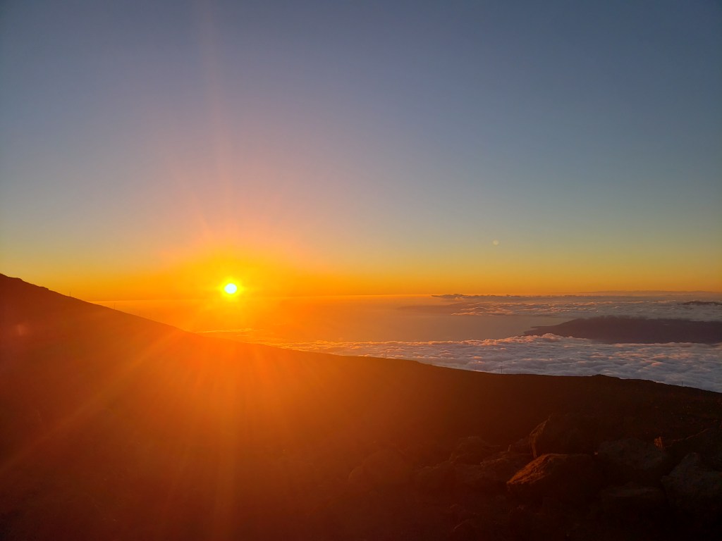
I really enjoyed my brief visit to Maui! So much so that in just a mere 60ish hours I did enough to warrant two posts! I had already been to the summit of Haleakalā (a little shy of it, actually) on Friday night, and Saturday was my Road to Hana and Kipahulu part of the trip. Sunday morning I got up nice and early due to my feathered friends’ wake up calls. I was not able to secure sunrise tickets at the summit of Haleakalā so I was aiming for a 7 o’clock entrance. The entrance is pretty far up the mountain so I still left around 6. 7 AM is when they let the peasants in, and let me tell you, I got to that gate at 6:47 and not only would she not let me in, she also told me I had to go about 100 yards down the road to be off national park grounds….ahem. Rude. Nevermind that it’s a good 20 minutes, still, to the summit! But ok. Anyway, at 6:59 she let me in and I made it to the actual real summit at about 7.20.
When I came up the mountain after I landed on Friday, the temperature gauge went from about 82 to 50. This morning though, it went from about 70 to THIRTY FOUR. BRRR. Thankfully, I had two jackets, long sleeves, gloves, and a beanie. It was super windy, so all of that was needed. Although I missed sunrise, 45 minutes or so afterward was glorious! This time I did manage to snag parking at the true summit part. You pass the observatory up there (which is not open to the public) and there is a parking lot with stairs leading up to an observation building which was closed, I guess due to covid. No bother, you could walk around the whole building and get the whole view without glass separating you from the elements. There was a little loop trail up there that gives you views of the entire surrounding panorama. From here you can see the Big Island, all of Maui, Molokini, Lanai, and the uninhabited Kaho’olawe.
I very nearly decided to go to school for astronomy. I have actually never ever seen an observatory before. This one is a fully working one, and not open to the public in any way. But can you imagine working up here!? Taken by me.
The summit, above the clouds, about 45 minutes or so after sunrise. Taken by me.
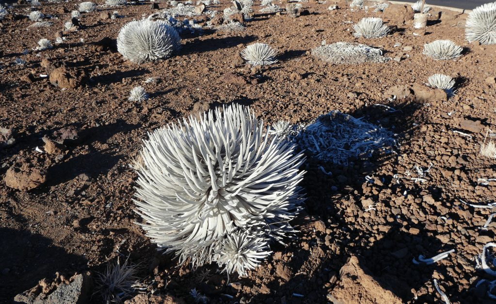
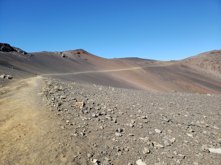
After checking out the upper park of the summit I drove down a bit to the summit visitor center and began the Sliding Sands Trail into the crater of the volcano! This trail is rated as hard, is 11 miles out and back and has a 2800 feet descent. I actually did not intend to do a ton of this hike, but once I started I was making such good time that I managed to make about 2.5 miles in and about 2000 feet of that drop before I turned back after rolling an ankle. I made great time to that point. But it was the way out that was the killer. The last mile to so, according to alltrails, sees grades up to 23 degrees! And it is no joke, especially on a busted up ankle! There is very little vegetation growing up there. Despite the barren and volcanic beauty of the rock and cinder cones, there are a couple plants that do thrive in the crater including a really pretty plant called the silversword. This is a species of plant only found on Hawaii, and this particular one on Haleakalā is an endemic subspecies. Pretty neat! They can live for decades and only bloom once, which does kill them. They are threatened because people used to dig them up to take home…… Anyway, this hike is totally exposed with no shade of any kind. With the sun beating down on you at high elevation, at the nastiness of the climb out of the crater, lots of water and snacks are an absolute necessity! It is a very strenuous hike! Did I mention this hike goes INTO THE CRATER OF A DAMN VOLCANO???? Anyway, I finally made it back to the visitor center, grabbed a shirt, my stamp in the passport, and started heading back down the mountain.
Cool view into the crater. This is actually pretty far into the hike. Pretty desolate! There are actually 7 or 8 of the crater’s 16 cinder cones in this picture. Taken by me.
These are the silver swords. This subspecies is only found on Haleakalā. Taken by me.
I really liked the colors on this cinder cone here! Taken by me.
This last stretch of the hike was killer getting back out! It doesn’t really look it, but the grade is as much as 23 degrees. My picture.
A view into the crater from the Kalahaku Overlook. The dark spot in the middle of the picture is an old lava flow! My pic.
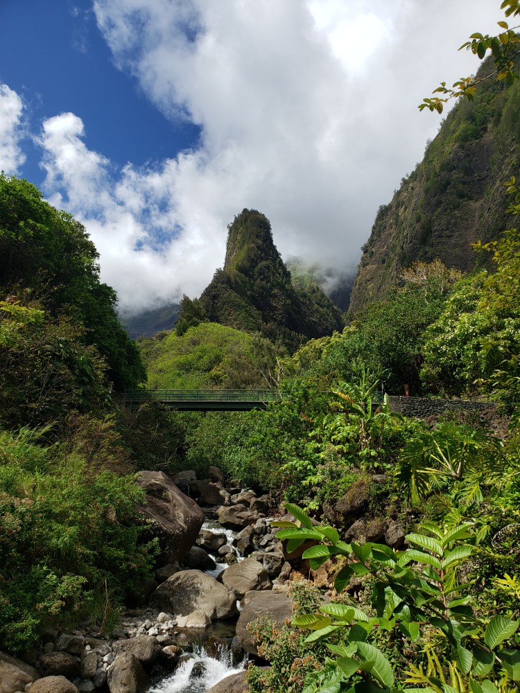
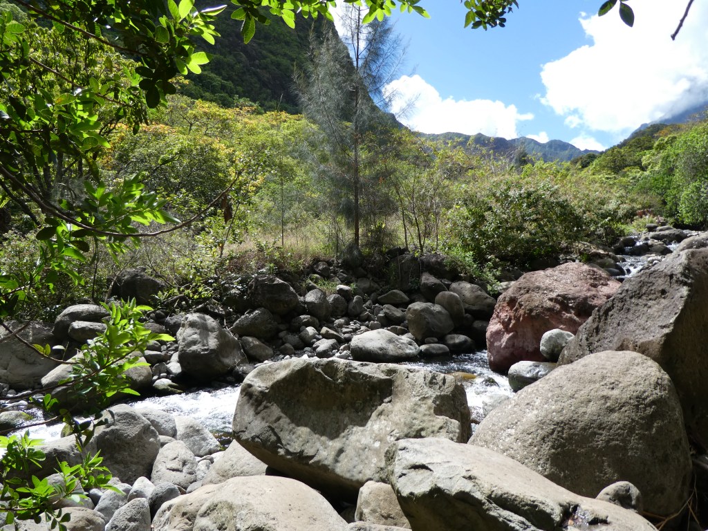
I said goodbye to the national park and headed back down to Wailuku and headed toward my next destination, the Iao Valley State park. This place was NEAT. The drive in is basically driving through a gulch of the old extinct volcano in west Maui. Tall cliffs, rather than the barren reds and browns of Haleakalā, totally covered in green fauna directed me in. The big draw here is the Iao Needle. This is a leftover lava remnant, and local natural landmark. The whole area is outstanding with a nice leisurely trail and some manicured pools and what not. There are some great views of the needle to be sure, but really the whole area is just as superb as the needle. This park has an entrance fee of 15 bucks if you park there. I spent maybe an hour as I found a little side trail into the wilderness that got me to a nicely flowing downhill stream to soak in the natural beauty.
The Iao Needle in Iao Valley State Park. Taken by me.
A view down the Iao Valley. Pictures really cannot do this place justice! Taken by me.
The quiet little spot I found to chill in Iao Valley. My pic.
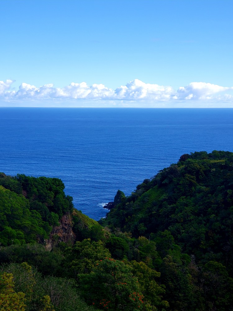
At this point I really had nothing left on my agenda, but I was going to head in the direction of west Maui and Kihei, which is where Maui Brewing is located. I turned on the Gypsy App, though, and let him dictate where to go. Instead of going to Kihei I turned up to the north and drove the road along the coast toward a town called Lahaina. This drive gave views of the back side of the west Maui mountains (as with Haleakalā, this side was a totally different and dryer environment than inside where Iao Valley was). This drive also was the access to all of the beaches along the road. In Hawaii all beaches are public! Nice thing to know, and it seems everyone was there! I continued the drive and was amazed again, at how close the other islands were, especially when Molokai came into view, to the north, because it looked massive from where I was, and I was not even all that close to the northern Maui coast! Anyway, at this point, I stopped to soak up some rays on this particular beach which was no sand, but mainly big lava rocks, then I headed back south toward Kihei.
Molokai from the beach I stopped at in west Maui, in Lahai. This was a park called Hanakao’o. Taken by me.
On this stretch I made the decision to take this road down as far as I could go, which would lead to a lava field. This drive also went through the really ritzy tourist area which was pretty, but not terribly natural. However, there were some nice beaches along this stretch as well. Upon getting down to the lava field though, it looked, again, like a different planet! They actually constructed a road through this field. It is very illegal to get out and do anything in the lava field, and I see no reason anyone would want to! This was the last lava flow from Haleakalā anywhere from 2-500 years ago depending on who you talk to. Getting to the end of the road however, there are some ocean access points among the volcanic rock where the lava met the ocean here, further building the island. Some of this rock was that black lava, and some was a much lighter color giving a nice contrast. Looking up the mountain you can see how big the flow was and even see the vents which provided the outlet. Super neat thing to see! To wrap my trip up, I sat down at the Maui brewery, caught the 4th quarter of the Super Bowl, then grabbed dinner in Kahului and called it a trip!
This was a spot I stopped at that is a potential whale viewing spot. I saw no whales, but I did see this cool view of Haleakalā. My picture.This is a spot where the last lava flow from Haleakalā met the ocean at La Perouse Bay. Take by me.
Overall impressions: Pros: Stunning scenery. A super nifty culture. Cons: It’s pretty expensive on the island for sure and it is not an easy trip from Florida!
The Adventurer Final Word: 5 Stars! Amazing. A definite must see, Maui, the volcano, the road, all of it!
Hey there fellow adventurers! It has been a bit since I last wrote! I have been very busy with work stuff and life in general. BUT, I did manage to sneak in a weekend trip to HAWAII! WHAT? I can hear it already! Weekend and Hawaii, those are two things that should never go together! Well, they did and it was fantastic! (If you are interested in how to get to Hawaii, as of this Feb, please scroll to the 4th paragraph with the big star!)
This will be my first two part post on a trip. I was originally going to do a Haleakalā post and a Maui post. Then I decided that was dumb, they are essentially one in the same. Then I got to the end of my first full day and realized that post was already SUPER lengthy. (There are some nice pics to be found after the first few paragraphs, fyi!) so the first day gets a post and the second day gets a post!
So this how this trip got started: Several months ago, I was sitting on about 25,000 Southwest points. If you check out my 2021 wrap up post, I traveled a LOT using Southwest almost exclusively and paying for exactly one flight of the bunch. That flight was my El Paso trip and the reason I paid for that was to extend my companion pass through this month of February. My sidekick was unable to come and really this was the type of trip that anybody coming with me would have probably wanted to kill me anyway…so cut to around the time of that El Paso trip and Southwest dropped a 40 percent off sale to Hawaii! I had not even considered because A) Southwest did not actually allow you to book or even see fares to Hawaii other than calling them. And B) I just assumed Hawaii was out of my price league for now. C) I was unsure of the whole travel to Hawaii procedure (more on that later) Well, with that sale I saw an opening for A and B. Southwest had finally started advertising fares with this sale and I found round trip flight patterns from Tampa to both Maui and the Big Island for 22,000 points! I only had two personal days from work available to me, so I found a flight landing there around 4 PM Friday giving me the entire evening with a couple hours of sunlight, all of Sat, all of Sun, and flying back early on Mon. Then began step two, rental cars and places to stay. I was very much aware of how expensive Hawaii is, so at this point I had a flight booked and for the next like 2 months I was not even committed to it, but I had my eyes on a few things. I eventually settled on a hostel and a car, which together cost me only about $450
The trip from Tampa to Kahalui, Maui, was lengthy, as you might imagine. As of the trip in mid Feb, to get to Hawaii is not as easy as getting on a plane and flying there. Also, this is my experience and of course check on your own, don’t take my word for it, it’s a very fluid and moving procedure! (Since writing that last sentence I have to delete part of my post since things have changed again regarding dining indoors!) You must be FULLY vaccinated for Covid (not only one or two doses) or provide a negative test recognized by the state of Hawaii. It is best to set up an account with Hawaii Safe Travels. You can upload your documents there and they provide you a QR code. With that code you get scanned either at the last departing airport or once you land AND YOU NEED THOSE DOCUMENTS WITH YOU. No copies either. With Southwest they had a counter in San Jose and did it there and provide you with a wrist band. That band was checked multiple times after landing in Kahului, by the way. It sounds like some airlines don’t offer that service and then you are stuck in a long like at the Kahului airport to get through. When I was indoors to dine, my vaccine card was required, and the hostel also required it, but as of Feb 24 I see that vaccine cards are no longer required for eating indoors. I will say that having the entire procedure done ahead of time was vital. The line of people in the Hawaii airport waiting to be let through was lengthy and I am very glad I was able to sail right through!
Anyway, back to fun stuff! I had never flown over the Pacific before. It was a long time to not see land! But finally, LAND HO! I was so relieved to see the Big Island start rising out of the endless blue ocean and then it was but a short bit until we were flying over the midsection of Maui! After grabbing my luggage I booked it to the rental car station. We landed around 3:30, about 30 minutes early, and I had about 3 hours of sunlight and my plan was to book it up to the summit of Halekalā to catch sunrise! The drive to the summit was lengthy and quite interesting. This side of the mountain is quite a bit dryer and not really tropical at all! It has to do with how the winds are hitting the island, that the western side is very grassy and dry, while the the other side of Haleakalā is one of the wettest places on the planet. As I drove up the 10,000 feet of elevation change, the temperature steadily dropped and the views became increasingly striking above the clouds! I think Hawai’i must be the only place in the country that you can drive from sea level to 10K plus feet like this! The only spot that I can even think of that you even look up at 10,000 feet of elevation change would be the mountains of the Alaska Range! Sorry Colorado! Looking at a 14er from 7K elevation is not the same as looking at 10K from sea level! I made it up to the parking lot just below the summit parking lot, which was closed due to too many people. In any event, the views were SPECTACULAR. I was unable to get sunrise tickets…not many are available…but sunset was quite amazing! From this exact spot you could see all of Maui to the north and west, the shadow of Haleakalā on the clouds over the ocean to the east, the observatory above on the legit summit area, and the crater of the volcano! Seeing the island from 10,000 feet above and not in a plane was pretty awesome! After the sun dropped below the ocean I was off to sea level again. Ninety minutes later I had settled down for food and beer at the Maui Brewing Company, then it was off to the hostel!
Sunset over Maui from Haleakalā near the summit. West Maui is on the right side past the clouds. The island of Lanai is visible in the middle top. My photo.
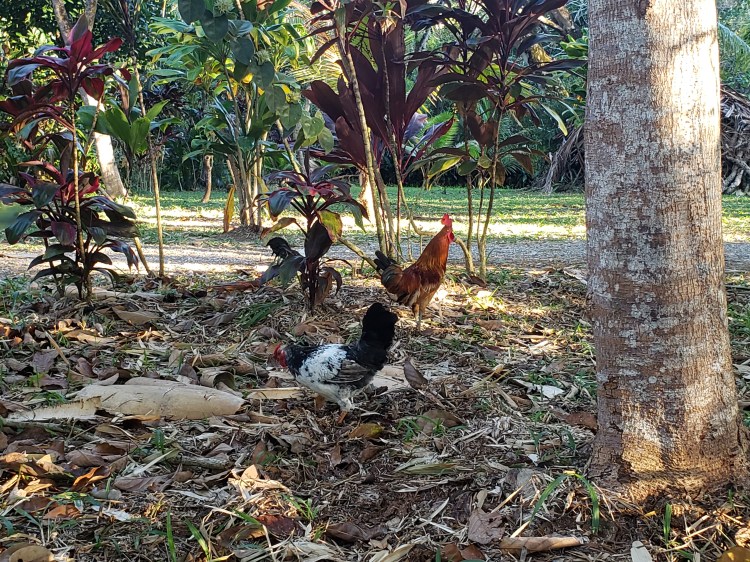
I stayed in the North Shore Hostel in Waikulu, just adjacent to Kahalui. What can I say? It was cheap and it provided a bed. I had never stayed in a hostel before. For three nights at the cost of one night in a regular hotel on the island it did the job! Good place if you want 0 amenities other than a shared bathroom, bedroom, and kitchen. Let’s talk about chickens for a minute. I live in a spot where feral chickens are occasionally annoying. These damn Maui roosters start going off at like 3 AM. SUPER ANNOYING. The hostel windows were not very thick. Something to consider, maybe, if you are a light sleeper!
Maui’s resident pests. My decision to still eat chickens remains solid. My photo.
I came to Maui without much of an itinerary. I had a rough draft of things to do, but didn’t really know how the timing would work out! Upon making a beautiful sunset at Haleakalā I decided Saturday would be my trip down the Road to Hana. The Road to Hana is listed in many resources as THE most scenic drive in the entire country. And is WELL DESERVED! This drive is a mere 50 some odd miles to Hana, and it can take HOURS!
The route along the Hana Highway past Hana and onto The Kipahulu District of Halekalā National Park, courtesy of google. Thats an average speed of about 20 MPH and that’s without stopping.
I started the Road to Hana, officially called the Hana Highway, around 5:30 or 6 from my hostel while it was still pre-dawn, and I’d say I made it no more than 10 miles before I had already stopped 3 times and spent an hour doing so! This road runs along the coast north to east along the more or less sea level section of Haleakalā as it descends into the ocean. The Gypsy Guide mentioned 6 HUNDRED and some odd curves and some 59 bridges of which like 50 of them are one lane and require careful interaction with other vehicles! As you drive, the right side is entirely tropical mountainside with breaks for GORGEOUS waterfalls. The left side is usually beautiful coastline/ocean vistas. I stopped for a few waterfalls, including the Twin Falls which required a about a 2 mile round trip hike (easy peasy but youy do have to walk through some water). This was found early on and is also private property so there is a convenient parking lot and attendants willing to take $10 dollars from you!
Ho’okipa Point. This was my first stop along the Hana Highway. This is also when I knew that the trip was going to take a while…gorgeous! My photo!
The Twin Falls. That’s not me in the picture. But I did take the photo.
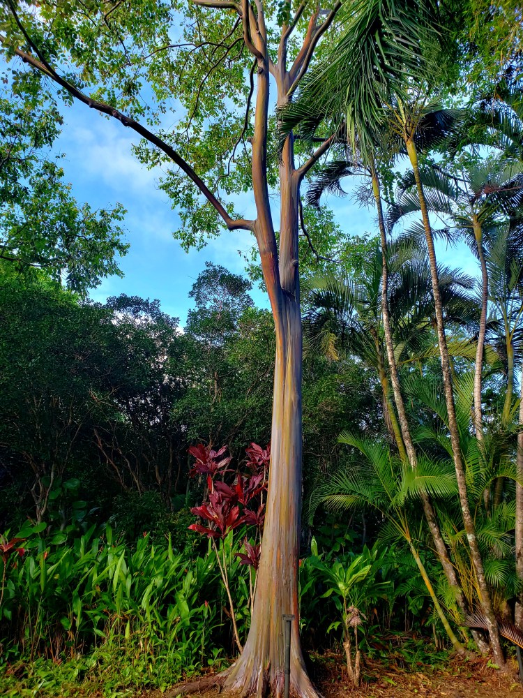
I also stopped to visit the Garden of Eden Arboretum. To be honest, this place kinda looked like a tourist trap and cost 20 bucks to enter, but was absolutely gorgeous. The grounds are stunning and include rainbow eucalyptus trees and also stunning views of the ocean, including (as they like to REALLY harp on) views of Keopuka Rock, shown in Jurassic Park.
A beautiful overlook of the ocean from the arboretum. And yes, that little rock pointing up…that’s Keopuka Rock. Which was very briefly filmed in Jurassic Park. And they are living off of that! Personally, the area stands on its own, but whatever. My photo.
I took this picture of a rainbow eucalyptus. The arboretum has several of these, and they are quite neat to look at! My photo.
Another lush view from the arboretum. My photo
After the stop at the Garden of Eden, I made the decision to not stop much more. However, the Gypsy Guide was ALL IN on stopping at a town on a sea level point called Keanae. The view here was awesome, at sea level, among volcanic rock. And, there is Aunty Sandy’s Banana Bread. This was what he actually wanted me to stop for. AND IT IS AMAZING. I ate almost all of it immediately. Its warm out of the oven when you buy it….omg. So good! After the banana bread indulgence I continued on my way to Hana. As a side note, I made a mistake here. There is a beautiful black sand beach along this road called Waiʻānapanapa Beach and unbeknownst to me, it requires ADVANCED reservations. So I could not go. I am not sure if this is a Covid thing or not, but just heads up! Upon getting to Hana I stopped for lunch and to get some beverages for my upcoming hike.
Me cheesing in front of the ocean on these lava rocks at Keanae.
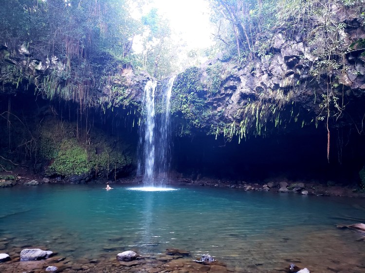
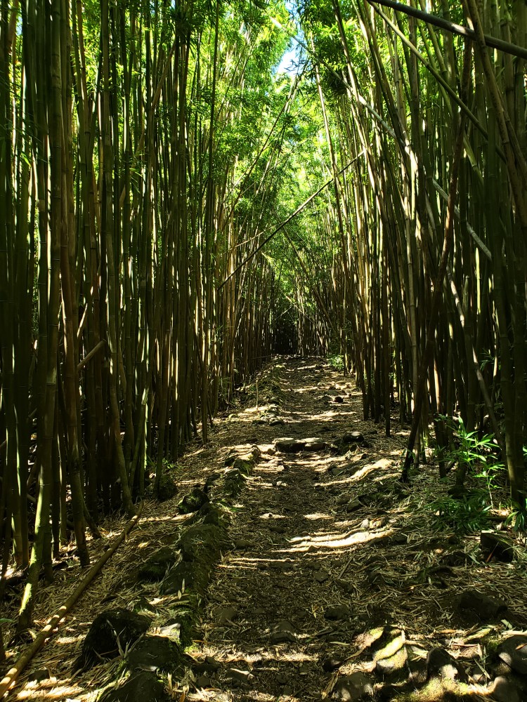
The National Park is actually accessible in only two places and they are pretty much as far apart from each other as can be. The summit access comes in from the northwest through the more populated area of the island. The other one is called the Kīpahulu District. This area is kind of a sliver of land from the coast up the mountain a ways on the southeast side. The only thing to do here, though, is some hiking and sightseeing. The Pipiwai Trail is the big draw here. This trail is about 4 miles out and back with 900 feet of elevation gain. Main things to see on this trail include a very large banyan tree, a bamboo forest, and a few waterfalls including the famous Waimoku falls and the Falls of Makahiku. This was a very pretty hike with lots of variety. Most of the elevation gain was right at the start up to the first waterfall, the Falls of Makahiku. Not far after that came the huge banyan tree. Past this are a couple smaller falls and pools and then a really neat trek through a bamboo forest. The sound the bamboo makes in the wind is really quite neat. The trail was not too populated, but had enough people that I was never really alone. The draw is to get to the end of the trail to view the 400 feet tall Waimoku falls as they cascade down a sheer volcanic cliff! A beer and snack later, and it was time to return. The Falls of Makahiku were actually quite underwhelming, even at 185 feet tall. I was on Maui during one the rare stretches that had to rain, so the falls were tall, yes, but not much more than a trickle. However these fall into the top of the ‘Ohe’o Gulch and lead into the Seven Sacred Pools which go out into the ocean.
The very large banyan tree on the Pipiwai trail. There was no way to get a better view than this. That big branch on the left side dropping another root, if that’s what you call it? That thing was about my size. My photo.
The bamboo forest part of the Pipiwai Trail. Photo by me.
Waimoku Falls at the end of the Pipiwai Trail. As I look at this photo I started to think the blue was the water and the vantage point was high. That’s the sky and the vantage point was from the bottom. If anyone else got confused about it! Photo by me.
After finishing Pipiwai I started down the Seven Sacred Pools Trail. This is a must do for some awesome views and is very short, only half mile loop with about 100 feet of elevation chance, mostly paved sidewalk and a few stairs. Here you can see the ocean come crashing on the black sand at the bottom of the gulch and look up the stream going up the mountain and under the road bridge above. Really stunning sight!
View point of where the ocean meets the black sands of the gulch. My photo.
View up the Ohe’o Gulch and the Seven Sacred Pools. That bridge is the road I drove over to get to this area. My photo.
After finishing my trails I was very tempted to violate rules of my rental car….but I didn’t. The Road to Hana actually changes to the Pilani High was past the Kipahulu part of the National Park down here. This road is predominantly one lane, can be unpaved in parts and generally not the best condition. It does wrap around the island and connect back to the middle of Maui, avoiding taking the Hana Highway back, but the guides say a tow from here can cost thousands so I decided just to traverse back the way I came, on the Hana Highway. Without making all the stops the drive was quite a bit faster but still, when they say to plan an entire day to make that drive and back, that’s legit. The earlier you start this drive the better and the more you can see! Upon getting back to Waikulu I grabbed dinner and a couple beers at Mahalo Aleworks, a really nice semi outdoors brewery with some delicious beers, and prepared for the early start the following day!
Happy 2022 fellow Adventurers! This post sums up my 2021, looks ahead to 2022, and will have some of my favorite pictures from my travels this year! 2019 was a very busy travel year. I did not think it would be topped! Of course with current events, 2020 was a low travel year and who knew what 2021 was going to bring. At the beginning of 2021 travel was still very uncertain. That being said, my 2021 ended up being my busiest travel year ever!
To wrap up: February saw the Adventurer and Sidekick check out Zion National Park, UT and the Valley of Fire State Park, NV. March saw the duo brave winter weather in Arizona to check out Sedona, the Petrified Forest National Park, Tucson, Saguaro National Park, and Mt. Lemon. April saw the Adventurer explore Cuyahoga Valley National Park, OH. In June the Adventurer and Sidekick went west again! This time Yellowstone and Grand Teton National Parks in Wyoming (and MT) were our target. The very next week a road trip saw the Adventurer’s loyal 4 legged friend become a Bark Ranger for the first time at Little River Canyon National Preserve and also at Russell Cave National Monument, both in Alabama. July saw the Adventurer and Sidekick brave the wilds of West Virginian and explore New River Gorge National Park. In September we hit the skies again to watch a pro beach volleyball tourney in Chicago, and then found ourselves in beautiful Acadia National Park in Maine. In November I embarked on a solo trip out west to see White Sands, Guadalupe Mountains, and Carlsbad Caverns National Parks in New Mexico and Texas. What a slate! I might add that nearly all of these flights were free!
How about 2022? Unlike last year, I came in to this January with one trip planned and at least 2 more in the works! First up will be a ridiculously short trip to Maui to see Haleakala National Park. Spring break in March is WIDE OPEN right now and I have no idea what is going to go there! In June I have booked a trip to Homer and Seward, AK to visit a small park of Lake Clark and Kenai Fjords National Parks. And then there is the rest of summer break! Those trips are just me. The Sidekick and I are planning tentatively to get to Fairbanks, AK for fall colors and hopefully some northern lights! I am going to guess that this will not be nearly as travel heavy as year as last, but I am super excited to check out some of Hawaii for the very first time and getting back to Alaska is super important to me! In addition to that free flight to Hawaii, I will have the June AK flight totally free with perks from my new Alaska Airlines business card. That card also gives a perk of a once a year companion fare for 120 dollars, so the second trip will essentially be a bogo. I will still have enough points on my Southwest account to sneak in at least one more free Southwest flight before I run dry!
In terms of this travel blog, I have a few new ideas. I am going to make a section featuring the entrance signs of and of the park units I stumble upon. I also really have enjoying getting good sunrise or sunset pictures in the parks as well, so I am thinking of doing a feature on those as well! And I still have catching up to do on some other travels, and posting itineraries in the hopes that they might be useful to someone in some way!
Here are my top pictures of the year, either taken by me or taken of me!
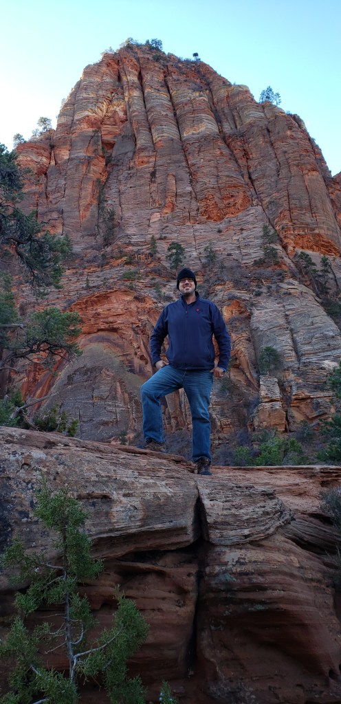
Along the Canyon Overlook Trail in Zion National Park, UT
Valley of Fire State Park, NV.
The Painted Desert in Petrified Forest National Park, AZ.
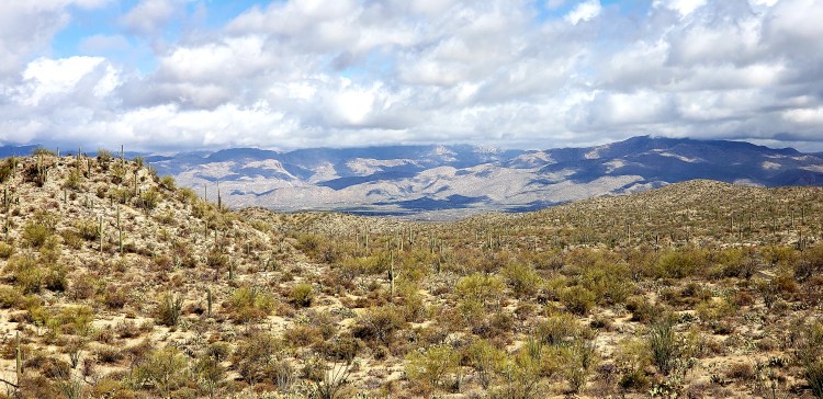
Saguaro National Park, AZ
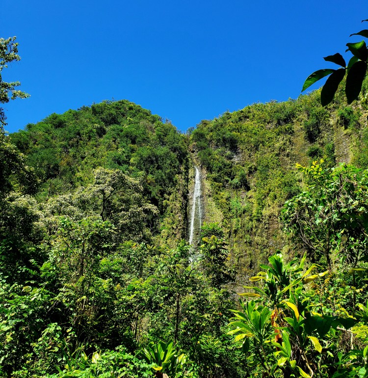
Blue Hen Falls, Cuyahoga National Park, OH
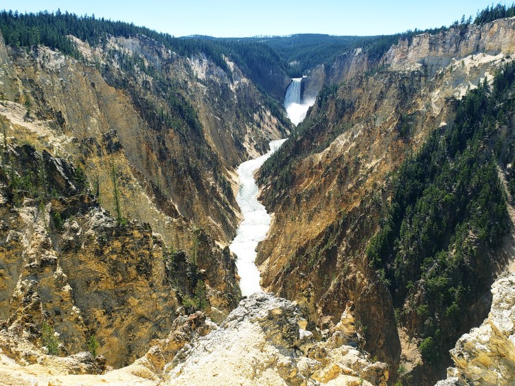
Lower Falls of Grand Canyon of the Yellowstone, WY.
Grand Teton and the Teton Range from Signal Mountain, Grand Teton National Park, WY.
The Sidekick and I in front of Grand Prismatic Spring in Yellowstone National Park, WY.
The newly appointed Bark Ranger Bella.
The Sidekick and I underneath the New River Gorge National Park Bridge, WV.
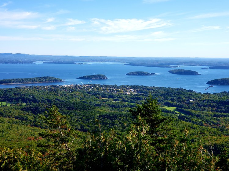
Acadia National Park overlooking Bar Harbor, ME.
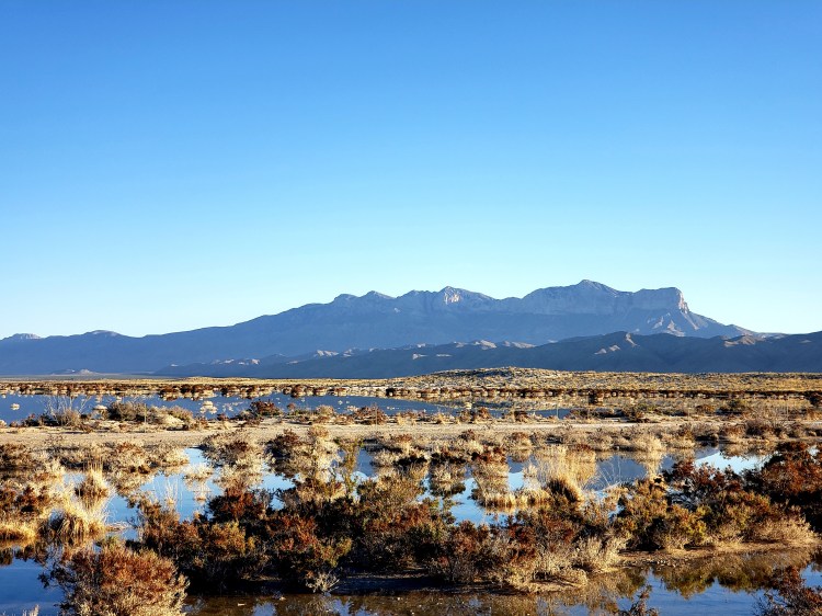
Salt Flats looking into Guadalupe Mountains National Park, TX.
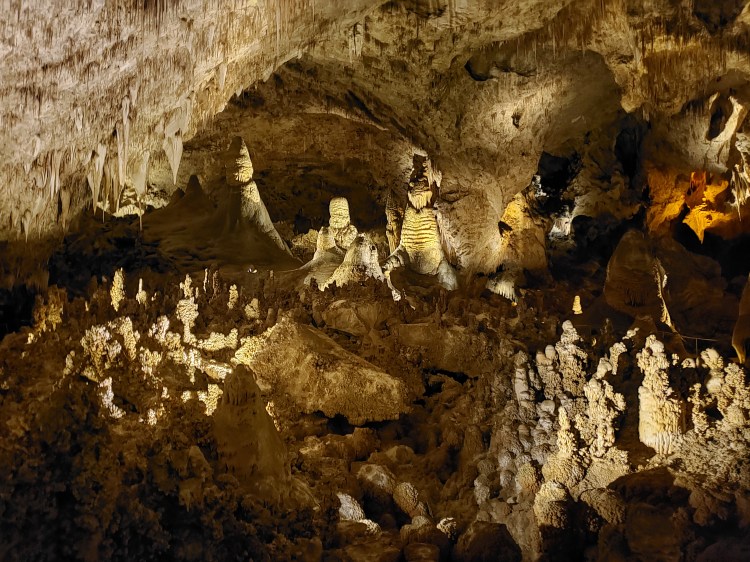
Cool scene in Carlsbad Caverns National Park, NM.
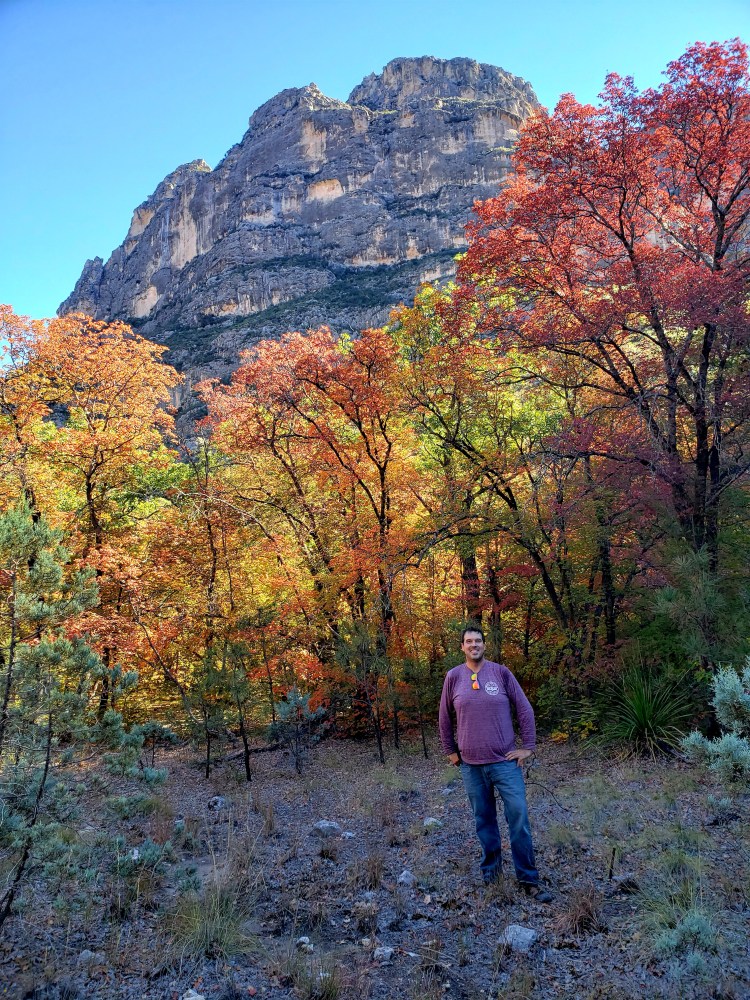
Cool foliage spot in Guadalupe Mountains.
White Sands National Park, NM.
Let’s have a great 2022 and do some cool shit and keep adventuring!
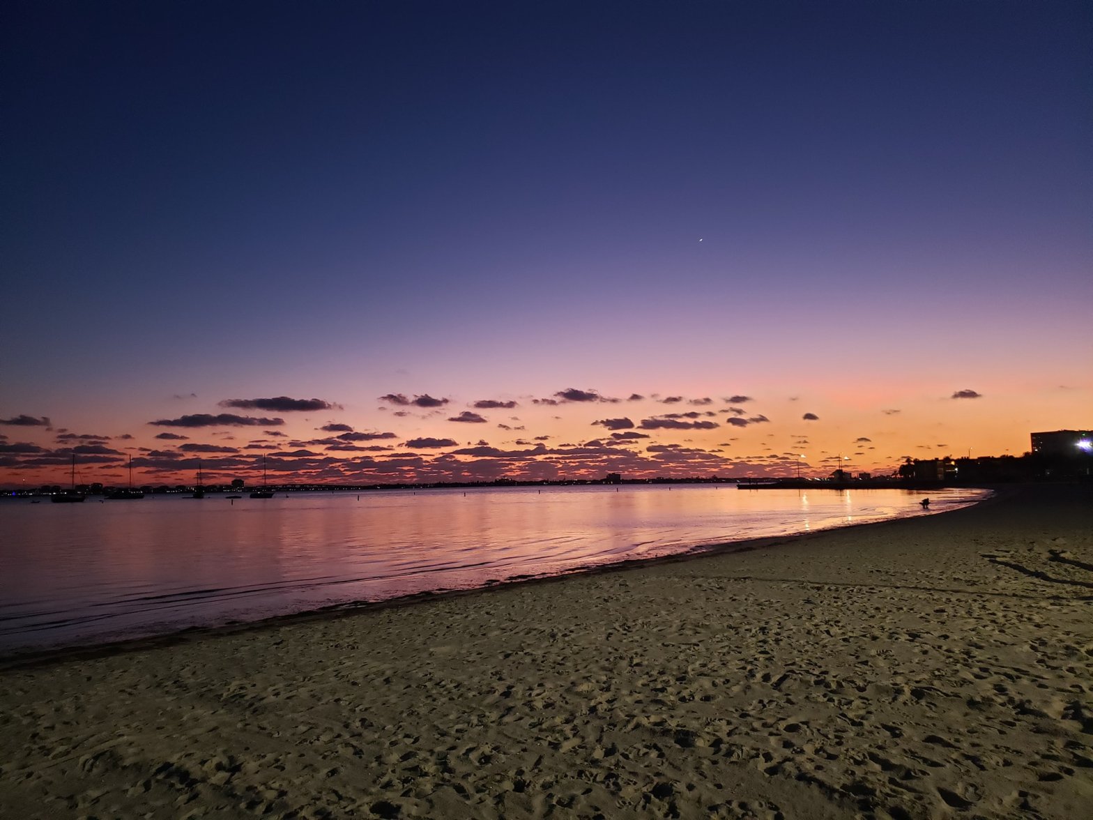
I hope everyone had a great Hanukkah, Christmas, or merely off-of work days last week and a great upcoming New Year! I haven’t done too much blog-worthy in a bit but I did get a short drive and a new “National Park” sign picture at the Blue Ridge Parkway in Asheville, and the Bark Ranger got her THIRD badge and the Sidekick has two Bark Rangers now! More on those to come! Meanwhile, the picture is one of my new favorites, taken on the beach in Gulfport, FL, only a few minutes from homebase! Enjoy the rest of 2021 and see you more in 2022!
Hey there fellow adventurers! If you have read any of my most recent entries, you know I did a New Mexico/Texas national park extended weekend trip! If not, then now you know and you can check out my entries on White Sands National Park and Guadalupe Mountains National Park. Park number 3 of this trip was Carlsbad Caverns National Park, found in a remote spot in southeastern New Mexico. There is no other way to say it: this place is spectacular!
This is about 10 minutes long, but there really was no way to give sense of scale or the route using pictures alone!
Also a Unesco World Heritage Site, this National Park was established as such around 1930 and is located in the Guadalupe Mountains, near the later designated Guadalupe Mountains National Park. There is a really neat native history to this cave and geologically the cave was once a part of the same reef leftovers that now make up that mountain range.
I can count on one hand the number of caves I have been to and none have been this stunning. I have been to Mammoth Cave and I rated it 3.5 stars out of 5 🙂 Nothing against Mammoth…it was cool and all, I just wasn’t that impressed. That being said, I went with my mother and we did a lite tour and now I am thinking a return and more serious tour might be in order. Anyway, back to Carlsbad! And, spoiler alert this one is a hands down 5 star spot! Firstly, I guess I was a little surprised at how undeveloped the area is, which is good! But still, it seems like a place that sees a half million visitors a year there would be a little more around, but I digress! I was also a little surprised that the drive to the cave was UP. I guess cave, down in the earth? Anyway, once completing the couple miles of that road to the visitor center I arrived at the visitor center.
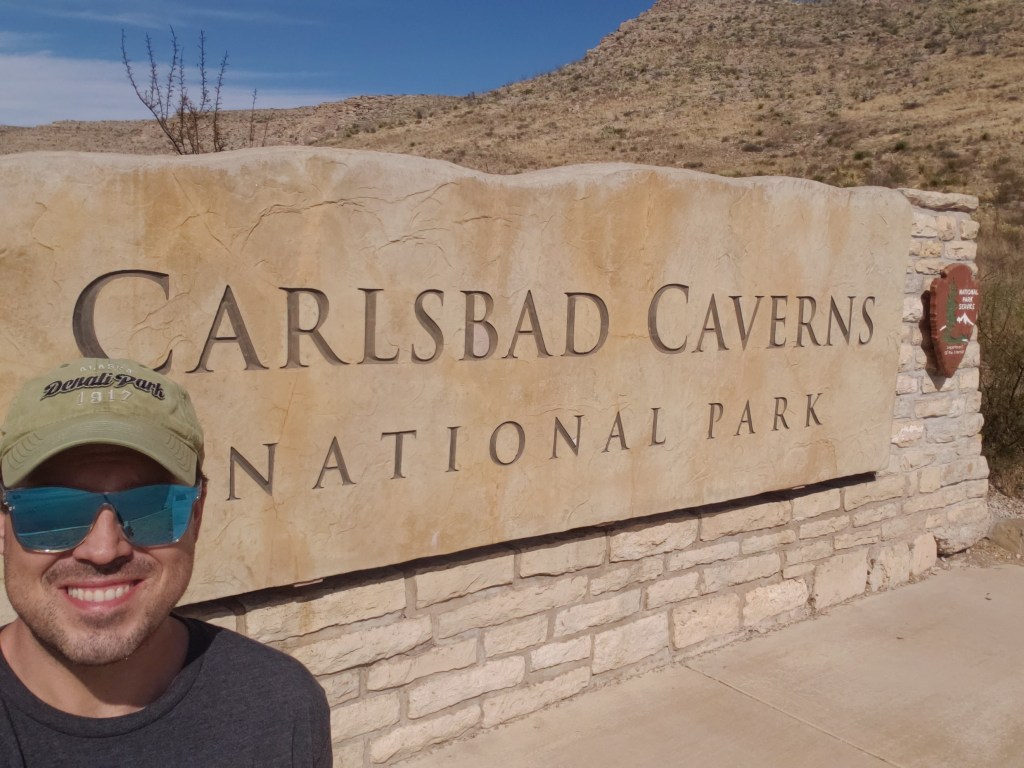
The required entrance sign selfie 🙂 Simple, yet powerful!
At this point I should point out the travails of this park with the covid situation. You absolutely must have reservations for the cave through recreation.gov. I have seen others saying that you can get walk up tickets…I did not see anything indicating that was possible. Also, the last tour must be started by 2.30 and the earliest tour starts no earlier than 8.30. Once you are in the cave you can stay until 4 or 4.30, I believe and you have to take the elevator out. To get into the cave you can choose the elevator down or to take the natural entrance.
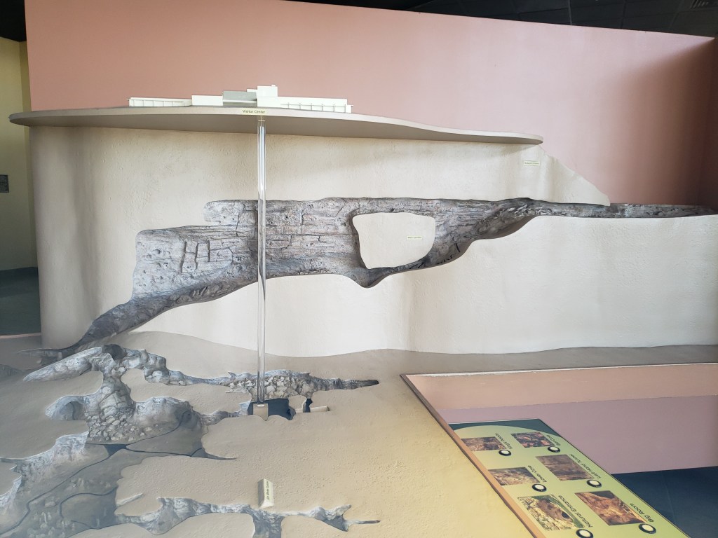
I was very interested in taking the natural entrance. However, I had already hiked almost 7.5 miles earlier, and the natural entrance is a mile or so at 750 feet descent, and supposedly takes an hour. A) I was tired and B) I wanted to be back at my campsite at Guadalupe Mountains National Park before it got dark and my timeslot was the last of the day. So down the elevator I went: 750 feet straight down! At one point this was the second longest single lift elevator in the US!
The 3D model of the cave inside the visitor center. You can see the natural entrance and that path and also the elevator shaft. And I took about half a dozen pictures of this entire model to try to trace the path through the whole Big Room
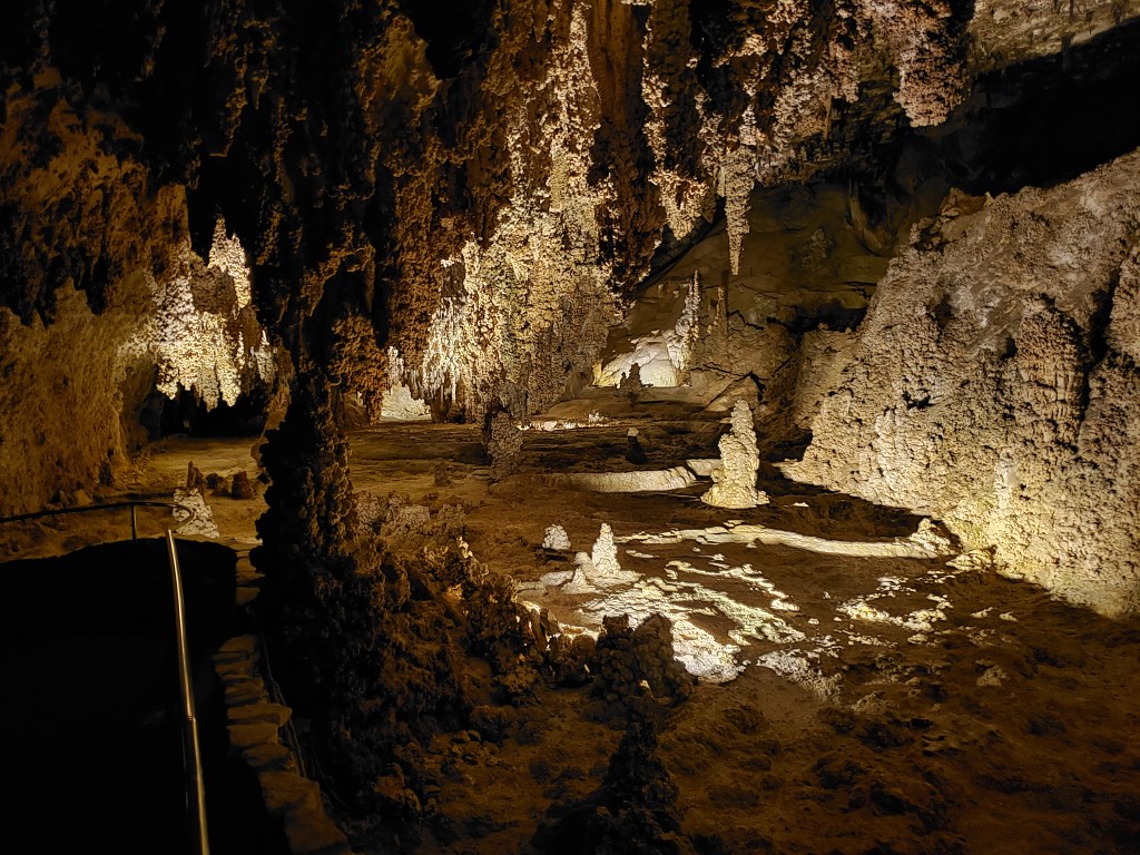
Here is where the jaw dropping started! Getting off the elevator you are in a fairly large open room with a gift shop, restroom, snack bar. I was already impressed! To be fair, Mammoth Cave is LOOOOOONG. Like, longest in the world and number 2 isn’t even close…but a lot of those tunnels are just that, tunnels, and the rooms are not particularly massive in size. This first stop was a BIG room. The “tour” I was on was the only one available in the time of Covid: The Big Room Trail. Fun fact, this room wasn’t actually even “it”! After going down the path a bit and seeing some cool stuff…you go through a small tunnel and then….here it is! The BIG ROOM. But even then, this STILL isn’t the biggest or most impressive part, not by a long shot! After going through this spot the Big Room finally opens up to a gigantic size! The path through all of this was 1.25 miles and I think the NPS makes it at the equivalence of SIX football fields! The one thing that I found to be really different between this cave and Mammoth is the sheer number of features/structures/formations, or whatever you want to call them. Mammoth seemed more tunneled out and with more floor space that was flat and walkable. I do not know if I am describing it correctly, but in Carlsbad it seems every surface, save for the path, contains some kind of formation or feature! I managed to get some decent pictures with my phone set to the night setting. Using flash was not producing any good results, and neither was adjusting the ISO, interestingly. Either that or my photo skills are lame ;)! The only thing about the pictures, is that they do not seem to really do any justice to the scale of this cave since there is not anything way to judge perspective. I took some video (see the youtube link up top!) and that really helps with perspective in my opinion! I am going to do a bit of a photo dump here now…I hope you enjoy!
This is an area early on, before the tunnel that takes you into the first part of the “Big Room.”
These were called the Lions Tail.
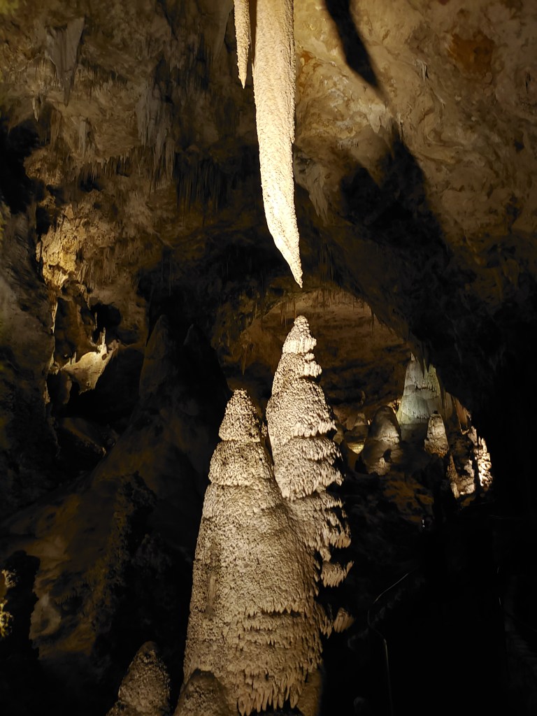
Hard to get a sense of scale here, but these formations are MASSIVE. This was called the Hall of Giants.
This area was called Fairyland.
This is called The Temple of the Sun.The Totem Pole and The Chandelier. Apparently I was a little shaky here…but this thing was tall…like 20 or 30 feet tall.
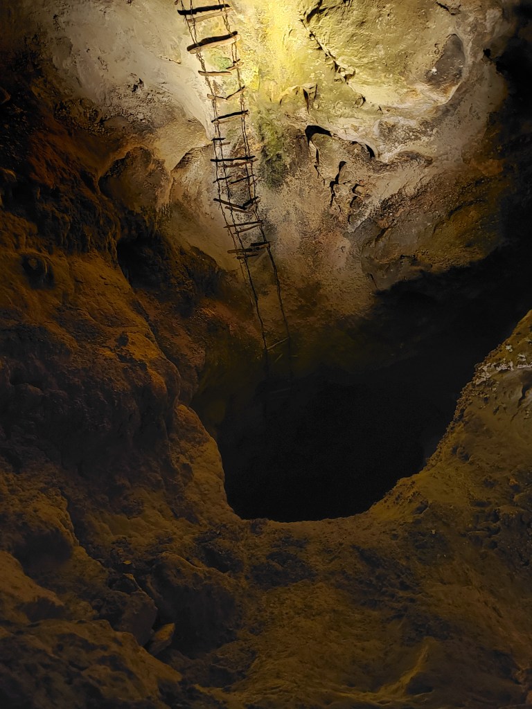
That rope hanging there is a fun story. They hung that rope to a balloon and let it ascend into a hole or crack in the ceiling. The rope then got hung on a rock or something and they deemed it safe to climb up and explore a new chamber above the Big Room!
And this contraption is what one of the earliest explorers of the cave used to get into that hole…no, thank you!
This is the Mirror Lake which is reflecting an Alien monster….
The Rock of Ages. Also HUGE.
The Chinese Theater, which was near the end of the Big Room Tour.
As I wrap up this entry, I should make note of the fact that this park is probably the first one that my experience may have been drastically altered by covid. There are normally other tours, including more “adventurous” ones that go down into the holes and further depths of the cave that I would absolutely love to come back and check out!
Overall impressions: Pros: The cave is amazing. Simply otherworldly. Cons: None for the cave. Not having ranger led guides and the other tours available is a temporary thing and in no way detracts from the experience!
The Adventurer Final Word: 5 Stars! Really awesome spot. I never knew I would be so damned impressed with a cave…but this did it. This is definitely a unique spot that is well worth the trip just on its own!